

Americans think that 100 years is a long time.
The English think that 100 miles is a long way.

There is nothing quite as exciting as a long driving trip. Hitting the highway, leaving behind the cares or the life of one place, and driving off into the landscape. This may also be a little stressful, with some fears of breakdowns, bad restaurants or motels, finding gas stations, bad weather, etc. I drove to British Columbia and back with my parents in 1959, and to Yellowstone and back with them a few years earlier. The British Columbia trip I remember rather well, the Yellowstone one dimly.
The following maps are the longest driving trips I've been on as an adult, usually involving moves, for a long time back and forth to Texas from Los Angeles, but then later transcontinental trips, between California and New Jersey, culminating in a permanent move to the East Coast. By then I had travelled quite a bit by other means, living in New Mexico (back and forth by plane, train, and bus) and Lebanon, seeing a good part of Middle East, with a long trek back to London from Beirut. I've detailed this elsewhere.
The original long drive here was moving to Texas in 1975. This was actually all the way  from Hawai'i with my first wife, Gaye. The first part of that, of course, was not by car. It did involve some subsidiary trips. Before leaving Hawai'i we flew to Maui and the Big Island of Hawai'i, and drove around them a bit.
  In California, we bought a car, a 1965 Volkswagen Squareback, and drove around California, staying with my cousin Jaci in Hanford, California, going to the Sequoia National Park, which I (let alone Gaye)
  had never seen, and then driving up to Berkeley to visit one of Gaye's aunts -- Sister Laola Hironaka (1926-2009), of blessed memory.
Then, loading up the Squareback, we set off on our heroic drive. Before leaving Honolulu, the boss where Gaye had been working for a while gave her a plexiglass clock, with a volcano and some other symbols of Hawai'i and Texas and "Hawaii to Texas" spelled out in gold plexiglass letters. It was very nice, but I think I only have one small image of it, on a shelf in our apartment in Austin.
The trip was planned to combine travel, tourism, and visiting. An easy leg from LA was to stay with my aunt and uncle, Lorraine and Dan, in Lancaster, then we hit the road in earnest for Las Vegas, to stay with my cousin Linda. 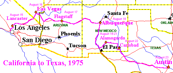 We were only there one night, but did get out to a show, which I think was at the Frontier.
Linda's husband also threw himself into some engine work on the car for us. The solenoid, which engaged the starter to the fly wheel, had been sticking. It had been possible to free it with a whack from a screw-driver handle, but he got wound up about buying a new solenoid and installing it. So he did. Very nice.
The next day we drove to Flagstaff. The last time I had been in Flagstaff was on a train in 1967, when the whole city was buried by several feet of snow. I was curious what the train station looked like without drifts of snow taller than a man. Well, a lot different than it did in August 1975. My original idea about staying in Flagstaff was that we could make a sidetrip to the Grand Canyon. I did not realize, however, how far the Canyon was, and that an extra day was really necessary for such a trip. So that was postponed -- all the way, as it happened, until 2003.
While Flagstaff was nice, the cold at altitude that night affected our battery, and we had to roll the car down the street to get it started. But we got going and then stopped for breakfast in Winslow, which I wanted to see because of the Eagle's song "Take It Easy," which has the line "standing on a corner in Winslow, Arizona."  There is now a sort of monument in Winslow to "Standing on a Corner," which I have subsequently visited. We got into Albuquerque that day, which I had left in 1968 and wanted to revisit. I didn't know at the time that a friend of mine I had been with in Beirut, Craig Nettleton, had moved from Minnesota to New Mexico and was living nearby. So Gaye and I were just on our own.
 From there we headed down to Alamogordo, where my aunt Jeannie and uncle Norman lived in a mobile home in the desert. This was actually near Tularosa, which is a few miles north of Alamogordo. We laid over there for three nights and saw some of the area, where I had been in 1962 visiting Lorraine and Dan (again), when Dan had been stationed at Holloman Airforce Base. This meant White Sands National Monument, of course -- as above with Jeannie and Norman -- the town of Lincoln where Billy the Kid shot his way out of jail, and a solar telescope in the Sacramento Mountains south of Cloudcroft. We had still been having trouble with the car, and bought a new battery. But there was something else wrong. The engine heads, of which there are two on the sides of a Volkswagen engine, had come loose. This called for a major repair, but the car actually made it all the way to Austin.
Norman showed me his brand new hand held calculator with red LED display. This was the new thing, and very fascinating. But I didn't expect I could afford one at the time.  After a while in Austin, I sank $40 to buy one. Now, of course, they are more or less a dime a dozen, with solar powered LCD displays; and everyone takes them for granted.
From Alamogordo we drove over the mountains to Carlsbad to visit the Caverns, the only time I've seen them. The Sacramento Mountains would become very familiar to me as the eastern flank of the Rockies. From there east, the land is flat all the way to the Ozarks or the Appalachians -- which do not compare as mountains even to the Sacramentos.
When we rose at dawn in Carlsbad and hit the road for Texas, it was a day of heavy portent -- not unlike the humid air that closed around us as mile after mile of Interstate 10 passed by. Hawai'i is humid, but not as hot and still as Austin in August. It was pretty bad, and we treasured the air conditioning at the Austin Motel (still there, by the way) on South Congress Ave.
As we headed down I-10 towards Austin, one thing I noticed were the limestone walls of the roadcuts. I'm not sure I realized it at the time, but the limestone was there for the same reason that the White Cliffs of Dover are limestone. Both areas were under warm shallow seas during the Cretaceous Period and both accumulated layers of the same kind of limestone from the same kind of creatures.
The fauna included the same large, sea-going lizard, the Mosasaurus -- among the first fossils to be discovered and recognized as extinct creatures -- first of all from Belgian mines, in 1764 near Maastricht. The story of the Maastricht Mosasaurs is dramatic enough, but it has a noteworthy, if not equally dramatic, counterpart in Texas. In the Texas Memorial Museum I would later encounter the "Onion Creet Mosasaur," a complete skeleton that had been found near Austin. For all we know, the Onion Creek Mosasaur might have swum all the way from Dover.
The climax of the movie Jurassic World [2014] is when a Mosasaur -- which we have previously seen in a Sea World-like show -- saves the day, rising out of the water and eating the evil genetically engineered dinosaur that has been wrecking havoc during the movie. At the beginning of the next movie, Jurassic World: Fallen Kingdom [2018], the Mosasaur escapes into the ocean; and it is later seen swimming around under surfers -- not yet eating them. So Mosasaurs are now part of popular culture and not just for museums anymore.
The last time I drove along I-10 in West Texas, in 2010, the roadcuts seemed to have visibly weathered. Not as clean and white as in 1975. I suppose that is to be expected. I am glad to have seen them when they looked fresh, even though I was not yet prepared to grasp their significance.
Four years later, with Gaye and I long separated, I was packing up to move back to LA. I had lived the same place all those years and had quite a few boxes of books and a trunk to send back. Even then many things, like furniture, had to be dispersed. What had been our bed went to, of all people, Joel Coen. The Squareback filled up again.

A couple of days before leaving,  while I was in a drunken croquet game at a party with my neighbors, I had a muscle spasm in my lower back. This literally put me down. One of my neighbors knew a chiropractor, who was willing to see me on a Sunday, the next day. His advice was (1) lie down, (2) don't sit, and (3) especially, don't drive. So I immediately drove to San Angelo, to lie down at Helga Hill's place. She was an old neighbor in Deep Eddy and was having her birthday party. I was in some pain but enjoyed it. We see her at right, at the time. Then I drove to Alamogordo, partially along the route (through Ft. Stockton, Pecos, and Carlsbad) that Gaye and I had taken almost four years earlier.
Helga kept in touch for many years, even after moving to the Northwest. She got into woodworking. After a while, she moved back to her native Germany and fell out of touch.
Back at Jeannie and Norman's, I could lie on my back for three days. That fixed my back (for the time being). Then I moved on to Albuquerque, where I had meanwhile learned that Craig was living. I had flown in and visited him and his first wife a number of times in the meantime. Unfortunately, Craig and his wife had just separated. He was a bit despondent and was drinking a good deal in the evening. This ended up adding something to my life. Craig mixed Manhattans, before moving on to straight Bourbon, and I rather liked them. I still drink them. We also did some other activities. The most memorable was hiking up to Sandia Crest, at 10,678 ft. A demanding hike, though Craig's companions kept ribbing him that we were using the "easy" La Luz Trail. Well, 10,000 ft. is 10,000 ft., especially when I had been living nearly a Sea Level for years.
I drove on in to LA in one day.  I had intended to spend the night in Flagstaff, but I got there by lunchtime. I ate at the
  Bob's Big Boy, which is no longer there (in fact, there are none in Arizona). So I figured I might as well go on to Kingman. It was only mid-afternoon when I got there, so I figured I might as way go on into LA. The only real problem was getting gas in Barstow. California had gas rationing, and I had to wait in a line (thanks to Governor Jerry Brown, whom the voters foolishly, indeed incredibly, returned to office in 2010). Very annoying. But it was still light when I rolled into the San Fernando Valley. Turned out to be the very day that John Wayne died.
After the summer in LA, I headed back to Texas, with somewhat of a lighter load. This involved an unusual stop in Arizona, a State where I didn't have any friends or relatives and so only stayed overnight at motels. A friend of Craig's I had met in Albuquerque in June lived in Prescott with his girlfriend. I arranged to stop off at their place. A quite nice interlude.

This resulted in a drive through parts of Arizona I had not seen before, up to Prescott itself and then through Jerome and Sedona to Flagstaff the next day. After another visit in Albuquerque, I headed down to Alamogordo again. The route I picked was over US 380 to Carrizozo, a road I later learned passed quite near Trinity Site, which itself I would visit in 1997. The dirt road from near Tularosa to my aunt and uncle's place crossed an arroyo just a few hundred feet from their driveway. When I arrived at the crossing on August 13th, there had been a heavy rain. Not only was the bottom of the arroyo deep in mud, but a County worker with a tractor, whose job was to clean up the road, had gotten stuck there. He asked me if I could call the County to get someone to come get him out. There was another route into my aunt and uncle's place, so I went around that way. We could call the County from there. But my aunt warned me that much more rain, and the alternative route in could get washed out also. I could get stuck there. So I decided to go on to San Angelo that day.  A rather longer drive than I had anticipated that morning, but it wasn't much after dark when I got in. From there it was a pleasant Hill Country drive into Austin.
Near the end of the Fall Semester in Austin, my father back in Los Angeles had a mild heart attack. I was also thinking that I wasn't getting much work done on my dissertation in Austin. I had spent much of the Fall writing a paper about Mahātmā Gandhi. So I got ready to drive back and spent some time in LA.

This drive only took four days, but I still liked staying with friends. My aunt was juggling relatives at the time, so I drove straight from San Angelo to Albuquerque, by way of Lubbock and Clovis, places I have never seen otherwise. From Albuquerque, I drove down I-25 and I-10 to Lordsburg, whence I turned off onto the scenic route of US 60 through Safford, Miami, and Apache Junction, Arizona. December, however, is not the best month for scenic driving, and it was quite dark by the time I got to Phoenix. I went through Mesa on the way in, and was astonished how much the place had grown since I was there in 1970. I gather it has continued growing since. I spent the night at a motel, left early, and got into LA by  noon.
noon.
I was in Los Angeles all of 1980. Sadly, my father died that May. By the Fall, my mother was able to get away on her first trip to Europe. Afterwards, my cousin Cheryl was driving in from Denver for the holidays and suggested that we get together and drive up to Mt. St. Helens, which had erupted May 18th. That sounded good. I flew up to Sacramento, and she picked me up at the airport, having left Winnemucca, Nevada, that morning. 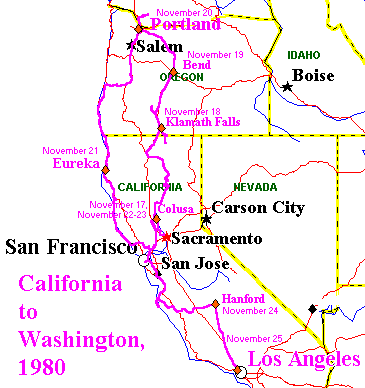 We spent the night with her aunt and uncle, unrelated to me, in Colusa, north of Sacramento. From there we drove up through the Sierra, to Mt. Lassen, down around Mt. Shasta, and then up for the night to Klamath, Oregon. The next morning we drove back into California to the Lava Beds National Monument, where Captain Jack of the Modoc Indians held off the U.S. Army. We even explored some lava tubes, which I have not otherwise seen outside of Hawai'i. From there we drove all the way to Crater Lake, which was closed to tourists and buried under snow. That was remarkable in its own right. Well after dark, we got into Bend, Oregon, for the night. The next day we drove into Portland to stay with my cousin Jo. From there we made our excursion to Mt. St. Helens. The whole area, of course, was still closed off. Our only hope was to get close enough at some point that we could even see the mountain. This we were able to do by driving up on the south side, which had not been devastated by the eruption, which was directed north.
On the way back we first drove down to Eureka. This involved some exciting driving on US 101 in the dark and the rain. With trucks going by trailing walls of mist, the road was often only visible because of the new reflective buttons that had been installed on the center stripe. Now, I was originally unable to precisely date this trip because I apparently didn't note anything about it on my calendars. However, I did know an event for the night we were in Eureka. The television season that year had been delayed because of a strike, and that night was one of the first shows of the new season of the television series Dallas: the memorable show where we found out Who Shot J.R. (Mary Crosby). That show was aired on November 21, 1980 (a Dallas website has the dates of all the shows), so that serves to determine all the dates of the trip. We needed to be back in LA before Thanksgiving.
From Eureka we spent a very long day coming down US 101 and then California 1 through Ft. Bragg to Bodega Bay (of The Birds fame). The coast road was long, narrow, and winding. We were very tired by the time we got to Bodega Bay, and Cheryl's dog, Scotch, a miniature collie, who had travelled very well all the way, got sick in the car. But we pressed on inland, all the way back to Colusa. We laid over there and took a day to go into San Francisco -- the last time I remember visiting there when it was easy to ride the cable cars -- now you can no longer just jump on in between stops. But we weren't done yet. From Colusa we drove all the way down to Big Sur, which neither of us had seen, and then over the mountains into the Salinas Valley, over the next mountains to Hanford, where Cheryl's sister Jaci (with husband and children) lived. After a nice night there, we came the rest of the way into LA.
That year, on Labor Day, my 1965 Volkswagen Squareback had gotten rearended and totaled.  I flew back to Austin after Christmas and then bought a new car that January, the 1972 Volkswagen Beetle, Yoda, that I still own. This was the year, 1981, of the Memorial Day Flood in Austin. Shortly afterwards, I hit the road for my most ambitious driving trip to date. My friend Helga no longer lived in San Angelo, so I headed for Dallas, where an old officemate from Honolulu, Bob Queyrouze, had relocated -- stopping off at the Texas Rangers Hall of Fame in Waco on the way.
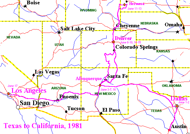
After a nice visit in Dallas, I drove across north Texas, through Childress and Amarillo, to Albuquerque. The High Plains thereabouts looked different from other parts of Texas I knew. And the Red River actually was red. I got off to a rocky start, however, getting a flat tire on the freeway in Dallas, in the dark and the rain early in the morning. Although it seemed dangerous and annoying (especially with the spare buried in the trunk under my stuff), I had had good practice in changing tires on Volkswagens, and later in the morning I stopped off to get the flat fixed. That day took 13 hours, which seemed at the time about the longest straight drive through I had done by myself.
Once in Abulquerque with Craig and his new girlfriend, I got to go along on a trip out to Cuba, New Mexico, to visit our old friend from Beirut days, Alan Campbell, who was working as a paramedic there. With Alan and his girlfriend, we visited Chaco Canyon, the only time I've been there. There had been plague in the area, and Alan was actually taken a strong antibiotic because he had been exposed to pneumonic plague from a guy who later died in Gallup.
After all this excitement, I drove up to Cheryl's own place in Denver. After touring around Denver, which I had not seen before, together we drove up to our aunt and uncle's in the Black Hills of South Dakota. This was quite a trip in its own right, seeing Mt. Rushmore, etc. After returning to Denver, I headed back to Albuquerque, this time along the scenic route up the Arkansas River, to the Great Sand Dunes National Monument, and through Taos, which I hadn't seen before (or since). A brief layover with Craig, and I drove down through Socorro and the valley of the VLA (the Very Large Array radio telescope), Show Low and Payson, Arizona, and then down to Phoenix. I was going to spend the night there, and it was sure hot, 110o. Unfortunately, the motels in the central city were all full with several conventions. After hunting around a bit, I decided to drive on in to LA. Without air conditioning, I poured water from gallon jugs onto paper towels to wipe off my face and arms. I was in  Blythe by dark and LA by midnight.
After the summer and the fall in Los Angeles, I was ready to head back to Austin for the Spring. This was going to be a no frills drive, more or less straight through, though with a stop in Alamogordo. I was going to try and get there in one day, but Yoda had different ideas. I noticed an unusual oil leak before leaving. By the time I got to Blythe, the leak was clearly into the clutch from the engine, and the clutch was slipping. Fortunately, there was a guy at the gas station in Blythe, Nacho, who was eager to fix it -- with the help of the VW service manuals. He actually did, though it took from 10 in the morning until 6 in the evening. While he was working, I checked into a Motel 6, where the heat didn't work (it was December) and the people at the desk didn't seem too concerned about it. So when the car was ready, I drove on in to Phoenix and stayed at a nice Roadway Inn near the airport. The next day was an easy drive to Alamogordo.

For the leg on into  Austin, I took a slightly different route, over the mountains to Roswell, then down through Abilene and Brownwood, to come down into Austin on US 183.
That semester I had a teaching job twice a week in San Antonio and spent considerable time on I-35, sometimes in ice storms -- it was a very cold winter, down to 12o in Austin that January. This would be the last stay in Austin, since I wasn't getting enough done working at other things. Poverty in LA to finish the dissertation would be worth it.
Another no frills drive, through Alamogordo again, and off to another rocky start. Straight through by way of San Angelo and Hobbs, New Mexico, but this time the generator bearing burned out in Artesia, New Mexico. Fortunately, the engine didn't actually freeze up until I pulled into a gas station. Although the closest AAA towing was in Clovis, the guys in the gas station said there was a local guy who worked on Volkswagens. He towed Yoda and dropped me off at a motel, which turned out to be owned by people from India, the first time I had heard of that phenomenon -- walking into the office, I was, astonished, bowled over by the scent of curry. I got a discount by paying him in cash, off the books I suspect, and he installed another generator. Not a new one, but it did last a year or so.
At my aunt and uncle's, near Tularosa, I noticed that a glass of iced tea, sitting on the wooden arm of a chair, left no water whatsoever on the surface. So different from Texas.
I woke up at 4:30 on the morning of May 20 and drove all the way to LA, by way of Over the next few years, I went along on a couple of one way drives. In 1983 I flew to my cousin Cheryl's in Denver. I had been flying back to Austin every year to consult with my dissertation advisor, Doug Browning, and visit. I finally finished and graduated in '85, but then went back for another visit by hitching a ride one way with my aunt Lorraine and my uncle Dan, who was going to one of his World War II fighter squadron reunions in Houston.
This was another no frills trip, but in an airconditioned Cadillac. The first day we actually had an easy drive to Phoenix, staying at the very same Roadway Inn I had used in 1981. The second leg stuck to I-10, and we stayed in Van Horn, Texas, in an area I had actually missed all the years of driving back and forth. My life changed quite a bit when I finally got a job, after some time on the beach, in 1987. With my new girlfriend and then wife, Jackie, we travelled quite a bit, partly by driving, but mainly by flying places, including Texas, New Mexico, Colorado, and Japan. That could involve local driving, even all around New Mexico from Albuquerque to Alamogordo and Santa Fe, but none of the really long drives I had engaged in earlier.
By 2003 it had been a very long time, more than 20 years, since I had done one of the really long drives, let alone done one by myself. Since I was beginning to plan for my retirement, when I could move back to Princeton, and I had a storage space full of stuff that I couldn't even get to, I began to think it might be fun, and useful, to vacate the space and move most or all of that stuff back right away. Books on shelves in New Jersey would actually be more accessible than books buried in boxes in storage.
So I rented a U-Haul truck. Providentially, my cousin Guy and his girlfriend offered to help load the truck. Without them, I think the job would have taken a whole day and perhaps destroyed me. As it was, it only took part of a morning, exhausting me and tearing some skin off a thumb, but limiting the trauma. That afternoon, I loaded some stuff from the house and garage, including things my friend Marc had left in the hope I could drive them to Atlanta for him. Driving around on these errands familiarized me with the truck. I had had no experience with such driving. The truck handled and accelerated very nicely. The main problem was getting used to the huge blind spot and learning to use the mirrors. It would take a while to be at all confident about that. And there was also the problem of just developing a sense of how large the truck was, for maneuvering and parking. This was a challenge, and I am still more or less surprising that I never hit anything along the way.
The trip was not going to be purely utilitarian. I not only wanted to visit friends but to revisit the past. My aunt and uncle in Alamogordo, high and dry, had meanwhile moved to Puget Sound, low and wet. They wanted a change, and that will do it. But I was still going to swing down to Austin, largely by the route that Gaye and I had taken in 1975.
The first day I was going to shake down just by driving to Kingman, Arizona. Leaving early in the afternoon, I did get slowed by heavy traffic on I-210 and I-15 in the Cajon Pass. I got gas and ate in Needles, and then found a Motel 6 in Kingman. This one seemed rather nicer than the Motel 6 I had experienced in Blythe in 1981. Awakening around 5 AM, I hit the road straightaway. Breakfast was in Winslow, as it had been in 1975. The place Gaye and I ate, however, was no more, and I had to go downtown. But I did find a nice restaurant there and even bought a "Standing on a Corner in Winslow, Arizona" T-shirt. I was driving through Albuquerque by midday, through because now my friend Craig and his wife were living up above La Tijeras, where I-40 passes between the two ridges of the Sandia Mountains just east of Albuquerque. My layover there was deliberately on the weekend, but it was too clever by half to be on a Sunday, since almost all the restaurants in Santa Fe are closed on Sunday. We went anyway, and ate at the Cowgirl Cafe, which was great.
I was expecting a very long drive from Albuquerque to Austin, but it actually only took 12 hours, and I got in well before dark. I had stayed a number of times at the Hyatt on Town Lake, and I went there again. It wasn't long before I was eating dinner (chicken fried steak, mashed potatoes, and black-eyed peas) with my friend Robert at Threadgill's on North Lamar. Unfortunately, since I was only laying over for one day, I couldn't do nearly as much visiting and eating as I would have liked. But it would have to do.
I did realize that one advantage of staying at a hotel or motel, rather than with friends, is that it is easier to get up and get away. I woke up about 5 AM again in Austin, expecting a long day. I had originally thought about spending the night at Vicksburg, but since it was only about midday by the time I got there, I decided to push through all the way to Atlanta. This ended up taking 15 hours. I didn't even stop to eat, snacking on bananas I had bought in Albuquerque and cinnamon rolls from the Little Czech Stop along I-35 in Texas. To drink I had Gatorade all the way from Los Angeles. Driving across the Deep South for the first time, outside the cities, I seemed to be seeing nothing but forest. Forest all the way from East Texas to Atlanta. Not exactly what I expected, but then I hadn't known what to expect. It was nice I did have airconditioning. It was dark and raining by the time I got to Atlanta and had a wild ride around the Beltway in heavy traffic. My friends Marc and Cathy were in Alpharata, a bit north of the city. I had not visited them there since 1984, when I flew in after my dissertation defense.
Unloading Marc's stuff and laying over a day again, the sightseeing was limited and the visiting the main thing. Fortunately, Marc was heading for the airport the next day, so it was less of a problem getting away early than it might have been otherwise. At that point, I was expecting to go the distance to Twenty years since my last long drive, this was altogether something different -- a drive right across the country, the LA River to the Delaware River. It was not bad at all. I had never had a problem with drowsiness on long drives. The only time I had ever experienced it was early in the morning. Later I would be wide awake no matter how long I went. Unwinding enough to fall asleep later tended to be the problem. My experience was similar this time. The cab of the truck was comfortable. It also helped that the 55 MPH speed limit was gone. Instead of pushing 60 on I-10, the speed limit there now was 75. Everyone was moving around 80. That sure added up. Even I-20 had a 70 MPH limit. Things only slowed down when I hit D.C. The next time, when I finally move back East, I think I'll avoid that city. Come 2009 and it was time to retire. After a year of frustrating and exasperating administrative stuff as Chairman of my Department, I was feeling particularly tied down and trapped. Then, getting off the plane from Newark in January, I was also feeling pretty sick of flying. I decided quickly that come June, and with my retirement, I was going to return to Princeton by driving straight through, no holds barred, as fast and as quickly as possible. Indeed, I had taken eight days in 2003, with detours and layovers. Now I would not even consider unncessary intermediate stops. How quickly could it be done?
Looking at the maps with distances and estimated drive times, I began to think that I could make the drive in three days. My DeLorme Street Atlas 7.0 gave a complete drive time as about 48 hours. That could be done in three 16 hour days. Long days, but do-able. It was constrained, however, by where stops could conveniently be made. Albuquerque was the only reasonable stop for the first day. I was even thinking for a while about going up to Dixon, New Mexico, almost all the way to Taos, the first day, since some friends from Austin had recently moved there. However, this was significantly out of the way, adding perhaps four hours on the round trip, so I stayed again with my friend Craig, who lived in a canyon above Tijeras, just east of Albuquerque, and all but within sight (and well within hearing) of I-40.
Leaving LA before dawn, but not before light, I was headed for I-210 but was warned off that there was an accident. So I ended up driving to I-15 on I-10, and hence to the beginning of I-40 near Barstow. It was actually raining a bit out in the desert, off and on all the way to Flagstaff. In all the years of driving back and forth to Texas, this was only the second time, after 2003, of taking the fastest Interstate route on I-40 to Albuquerque. Stopping off for lunch in Flagstaff and for some gifts at the Meteor Crater, I made it to Albuquerque in 12 hours, 13 by the clock with the time change. Craig and his wife took me out for pizza to a nearby place with a Grateful Dead themed decor.
The next day was into Terra Incognita, since I had never been east of Amarillo on I-40. Western Oklahoma looked more like Midwestern farm land than like the High Plains of the Panhandle, but then eastern Oklahoma, along I-44, was hilly and wooded. Not what I expected. I had breakfast at a Stuckey's in Texas and then lunch at a MacDonald's on I-44. I was hoping to make it all the way to St. Louis, but by the time I got to Springfield, Missouri, there was clearly not enough daylight left to go that far. So I stayed at a Ramada Inn there. It had been 13.5 hours that day, and I just had a banana and some snacks by way of dinner.
I was up about 4:30 the next morning and left in full darkness. If that was morning rush hour in St. Louis, it wasn't worse than a bit of slowing. I got a brief but dramatic view of the Gateway Arch as I neared and crossed the Mississippi River. Most of Illinois, Indiana, and Ohio where then farmland. Craig thought it would be a pretty boring drive, but I enjoyed the landscape anyway. My complaints where (1) that the exit for gas at Highland, Illinois, meant a four mile drive off the freeway, and (2) in passing through Columbus, Ohio, I-70 narrowed down at one point to one lane, which backed up and slowed down considerably. This struck me as one of the worse bits of road design I've ever seen. Indianapolis, on the other hand, made for a nice drive past some handsome downtown buildings. I only stopped once to eat, in Indiana, but otherwise snacked on bananas in the car.
I didn't realize until getting close that I-70 passes through a finger of West Virginia, at Wheeling. This was also a very winding stretch of the freeway, with speeds down to 45 or so at some points. Getting into Pennsylvania, I was soon on the Pennsylvania Turnpike. By then I had been on the road more than 12 hours, with the whole width of Pennsylvania before me. But I couldn't imagine stopping with only that left before the end. It took longer than I expected, a good six hours. I got into Princton at midnight, eighteen hours after leaving Springfield, Missouri. That was the longest day's drive I'd ever done, beating the old record by two hours -- for a total since LA of 43.5 hours, 4.5 hours better than the Street Atlas estimate.
The final stretch was not without its misadventures. I didn't have a very good idea what the distance was going to be. I didn't want to stop and take the time for a close study of the map, and the Pennsylvania Turnpike very unhelpfully does not feature destination and distance sights -- count this as complaint (3). I only remember one sign actually announcing that the road was headed for Philadelphia. Otherwise, distances were only given to the next couple of exits. As it got dark, I could no longer glance at the map to see how far each exit was from New Jersey. I could have stopped to use the map, but I couldn't see spending the time on something that didn't matter anyway. So I lived with the frustation.
As it happened, I would have been better off checking on the map, because I was laboring under a confusion about the Pennsylvania Turnpike. I knew it went all the way to the Delaware River and joined up with the New Jersey Turnpike there. That was the route I planned on using. However, I was laboring under the misconception that it coincided with I-76 all that way. Approaching Philadelphia, I was suddenly faced with an exit for I-76! This was confusing and alarming, and I almost darted across traffic to go that way. Mercifully I didn't, or I would have ended up going in the wrong direction and entangled in downtown Philadelphia. The Turnpike continued as I-276. I didn't know what this was, or where it was really taking me, but the signs did say it was headed for New Jersey, which sounded good -- as indeed this was actually the route I intended on taking.
Eventually I-276 crossed US1. I got off there, not because I really wanted to go up US1, but just because I would know exactly where I was, without even checking the map. US1 soon cross I-95, which I also knew, so I ended up crossing the Delaware on I-95 [which now in 2024 is I-295] and exiting onto the very familiar stretch of US1 north of Trenton. According to the Street Atlas, this was supposed to be the shortest route anyway. So by midnight I rolled into our driveway, a little late and a little confused but never actually, as it happened, lost. And then I was only late because I had underestimated the distance by an hour or an hour and a half. Not bad after getting up in the middle of Missouri that morning.
Those last few hours, however, did reinforce my dislike of driving at night. Not only does it make it more difficult to consult the maps, but with the landscape invisible, it removes all the charm of cross-country driving. I might as well have been on US101 driving through Thousand Oaks, California, as on the Pennsylvania Turnpike. Fortunately, the stretch of the Turkpike east of Harrisburg I had been over before, so I wasn't missing land I had never seen, but that didn't make that part of the drive any more enjoyable.
Eventually the day approached to head back to California. I wanted to take a little more time for that and along the way visit my relatives in South Dakota and my friends in New Mexico. With the post office holding my mail for only 30 days, however, I begrudged the deadline and hated to spend time on the road that I could have been spending with my wife. So the compromise was for a six day drive. The detour to South Dakota would add another very long day's drive to the trip and significantly more miles. The first day was all Turnpikes all the way to the Illinois State Line, starting with the New Jersey Turnpike, then the Pennsylvania Turnpike, the Ohio Turnpike, and finally the Indiana Toll Road. This was all straighforward and convenient, and it began with the route I had intended to take when coming and then the stretch through Pennsylvania I had missed in the dark. The on-road service areas in general are nicely spaced and eliminate questions about where to get gas or get something to eat (although it can be a bit disorienting -- Twilight Zone distorienting -- when the service areas in one State are absolutely identical to each other, one after another). As it happened, the only meal I had was lunch, in Ohio, otherwise snacking again on bananas, the gingerbread my wife had baked for me, and some other items.
The moment of decision came at Chicago. I planned on going all the way to Madison, Wisconsin, that evening, where I had even made a hotel reservation. It had taken about 12.5 hours at that point, gaining an hour with the change to Central Time. The AAA had recommended bypassing central Chicago on I-294, but I had never driven anywhere near downtown Chicago, and I-90 went right by it. I decided to risk the traffic and stay on I-90. I needn't have worried. The traffic was easy going into town. And I got a close and impressive look at the Sears Tower. Coming out of Chicago was then terrible, but the worst of it, beyond O'Hare, was well past where I-294 rejoined I-90 anyway. So I needn't have worried about the bypass, but I was dreadfully slowed by the traffic, which remained heavy all the way to Wisconsin.
I later realized that I was trapped in the Friday flow of people getting away for the weekend. There were a lot of boats on trailers headed for lakes in Wisconsin. So the whole day took a good 16 hours, though I was still into Madison well before dark. I had a hotel just a couple of blocks from the State Capitol. I wanted to go back there since I had only seen the city in a deep freeze at New Year's 1986, when I flew in to visit some friends from Texas who were living there for a while. Indeed, lakes with water look very different from lakes covered by ice; and Madison enjoys a lovely location.
My enjoyment of the views, however, was brief. I was up by 4:30 again. Still some boats on I-90, but a much more pleasurable drive. I had not been eating much in the way of breakfast on the road (not since Stuckey's in Texas), and I was now dermined to change this. I found a place in, I believe, Mauston, Wisconsin. It was a great breakfast. They even had hash brown potatoes, which I have not been getting at the places I typically eat in LA or Princeton. That, eggs, and sausage kept me going, with snacks, all the way to the Black Hills. After crossing the Mississippi at, well, La Crosse, Minnesota at first was hilly and forested. Then it flattened out and I saw something I had not previously seen: mile after mile after mile of extensive corn fields on both sides of the highway.
The farms from Oklahoma to Ohio to Wisconsin seemed much more broken up and wooded. This was more like North by Northwest fields, which perhaps is the way Iowa looks also. Getting into South Dakota, that began to change. The land dried out, becoming pasture and then praire. The long rolling plains were a landform, the High Plains, I had not seen since the Texas Panhandle. Then mountains appeared on the horizon, the Black Hills. I had not seen something quite like that since leaving the Sandias at Albuquerque.
I had not been back to my relatives' in South Dakota since the 1981 trip detailed above. A lot was familiar, but there had been changes, new building, and I was not remembering other details well. After a long day since breakfast in Wisconsin, we had dinner at the pizza place in Hermosa run by my cousin Jim and his son. The next day, my cousin Linda (whom I had visited in Las Vegas in 1975) drove me around, to Rapid City, which I had not actually seen before, and then back down by Mt. Rushmore, the Crazy Horse monument (showing some progress), and the city of Custer.
Ready to drive back to New Mexico the next day, I woke up at 2:30 that night and couldn't get back to sleep. Well, I might as well be on the road. So I was on a very dark highway at 3 AM. But there was some good moonlight. By dawn I was well into Wyoming, where I stopped for breakfast in Wheatland -- the Wheatland Family Restaurant I think it was. Even better hash-browns. Without absolutely no one on I-25 around me in the wee hours, I tried taking the Mini Cooper up to 100 mph. It felt fine, but I didn't want to temp any unwanted attention. Getting into Colorado, I managed to hit Denver right around morning rush hour. There was some slowing, though that seemed to be the result of a couple of accidents. Nevertheless, the traffic and the whole freeway system, now with a tollroad, seemed much greater than I remember from my last time in Denver, in 1992.
South of Denver, they were working on I-25 a lot. At one point it was even closed, with a detour through Walsenburg. The two traffic lights in the town were not adjusted for the new traffic flow, which reduced motion to a crawl going into town. Not very considerate or responsible on the part of the traffic authorities, who should have realized what a jam that would create. No such delays in New Mexico. So I arrived in Santa Fe 12 hours and 45 minutes after leaving Hermosa, South Dakota. My friends, however, lived in Dixon, New Mexico, another hour north of Santa Fe, at a place without an address. I needed their directions and, being much earlier than they expected, they were out shoppping. Since Dixon was also in a cell phone dead zone, I had to return to Espanola to wait and contact them by phone. So after a bit of comical delay, I eventually got connected, met up, and followed the way to their place. The next day we went in for a great visit to Taos, which I had driven through once, but never in all my days in New Mexico had visited properly. So we saw the Pueblo and various other sites, having a supremely terrific New Mexico lunch at a place called Orlando's. I said it was already perhaps the lunch of the decade.
After dinner that evening, I thought I would get a head start by going ahead down to Albuquerque and spending the night in a hotel. Since that was a 1 hour and 50 minute drive, even without traffic, it did enable me to be on I-40 the next morning at 5 AM again. After such a hearty breakfast, I went the rest of the way into Los Angeles. From Albuqerque, it was 8 hours to the Colorado River and then 4 more hours to home, arriving at 4 PM after the time change, and beating most of the heavier traffic. A fine finish to a most gratifying adventure. I was hoping to have a late breakfast at Jack's restaurant in Bishop. I got there about 11 AM, but the place was jammed. It looked like the most popular restaurant in the Valley. Susanville was a part of California I had never seen. Indeed, I'm not sure I had even heard of the town previously. Besides the sights, one reason I drove the eastern side of the Sierra was to avoid the heat in the Central Valley. Coming down into Redding, the thermometer shot up. Over the next couple of days, records may have been set, but I was comfortable in my aunt and cousin's air conditioned houses. My wife flew back to Princeton, and I needed to decide how I would follow her to spend the holidays there. I had not made plane reservations, and it was getting to be too late to do so for reasonable fares. But I was weary of air travel again, especially after the flights of many hours it took to get to and from Japan. I had also been wanting all Fall to visit Las Vegas, where I had not been in 1996. So I decided, with some trepidation, to drive back to Princeton again.
A couple nights in Las Vegas was a good start. In 1996, we had celebrated our 5th wedding anniversary at the Sands, a month before it closed. So this time I stayed at the Venetian, which was built on the site. It is gargantuan, but I enjoyed it a lot. I also took full advantage of the time to see the Blue Man Group for the first time, and the Circe de Soleil adult show, "Zumanity." I drove to Denver in one day, leaving before sunrise and arriving after dark. At right is Hotei, like the Roaming Gnome, parked at a Scenic Overlook off I-70 in Utah. This snow-covered landscape was something I felt I had often seen from the air at that time of year, but it was very different, vast, cold, and lonely, from the ground. It felt like the Roof of the World, even though the mountains in Colorado were higher than in Utah. I-70 in Colorado, however, seemed mostly to go through canyons, and it avoided the summit of the Front Range with the Eisenhower Tunnel. It was dark by then, but it was land I had also seen several times already.
In Denver, I spent the night at the historic Brown Palace Hotel, where my wife and I were for our first wedding anniversary. I felt like a vampire, since I was up and on the road before dawn the next morning. I did not see Denver in daylight this trip. The next drive was not as long, or scenic, but also with a goal of greater significance. I was in Kansas City well before dark and stayed at the Marriott on 12th Street, where I had been with my mother in 1998, on her last trip.
This time, my goal was Arthur Bryant's Barbecue, which I had missed in '98. I was a little concerned that it might be the sort of place to be closed on a Monday night. No problem. My only regret is that I couldn't finish the beef sandwich that I ordered. It seemed like a crime to leave all that food. But I was certainly impressed, pleased, and full. The hotel was all but vacant in those last days before Christmas. The taxi driver who took me to Bryant's had not had a fare all day and he waited for me while I ate. I was the only customer in the hotel bar later, and the woman playing the piano expressed alarm when I left after only one drink. But I had to go back to my room to e-mail my Congressman not to vote for Obamacare. Like he was going to pay attention to me -- and didn't. I still couldn't see sitting in some strange motel watching television, when I could be sitting in the car watching the road instead, and arrive home to our own bed. Of course, it is all right to fall asleep watching television, but not watching the road. Nevertheless, however imprudent they may be, I really don't get sleepy on such drives. So now Hotei got to sit out in the snow in New Jersey. The drive back to LA in January 2010, like the stop in Kansas City, had eating goals. Slipping in between the weather fronts, driving up the lovely and historic Shenandoah Valley, and stopping for the night in Knoxville, Tennessee, my first destination was New Orleans, which I had not seen since 1997. I wanted, of course, to check out and support the post-Katrina City, but I also wanted to see how well I had done with my Shrimp Creole recipe, which had been inspired by what I had had in a French Quarter restaurant.
I wasn't even sure if I could find the same restaurant, but I did: Not content with one comparison, the next night I had Shrimp Creole again at the Desire Oyster Bar on Bourbon Street. The comparison was instructive. The Desire dish had much more in the way of shrimp and vegetables, more like my dish. But it was not (spicy) hot at all, and I think this seriously detracted from the taste. And I had some indigestion. So I felt considerable satisfaction about the eating goals of the trip.
Meanwhile, of course, there was the extraordinary experience of the French Quarter and Bourbon Street, with its own unique combination of eating, jazz, booze, and strippers. I don't know anyplace else quite like it. This was in a hotel on Bourbon Street, with French doors along the street and a island bar inside along their length. Across the street was a strip club with a large sign of a red brassiere, with the caption "Stimulus Package." This was a reference to the so-called economic "stimulus" that the Democrat Congress passed early in 2009, supposedly to help economic recovery. As we know, the money mainly went to Democrat rent-seeking constituent groups, like public employee unions, and to fiscally irresponsible Democrat State and local governments. This didn't help economic recovery very much. It never does.
The irony of it, of course, is that while "trickle down" government spending fits the Keynesian narrative, Say's Law, which is about money that goes directly to starting businesses and hiring people, is disparaged as "trickle down" economics. The Bourbon Street "Stimulus Package," however, was much more effective -- certainly when the bras come off.
I don't think of "gentlemen's clubs" as very gentlemanly, but I had to see at least one stripper in New Orleans. Unfortunately, or fortunately, I was the only customer in the place, at midday, so the one lady gave me all her attention. I gave her some money but then soon beat a retreat.
From New Orleans, I drove to Austin. I wasn't able to avoid all the weather, since it rained steadily from Houston to Austin, but at least with temperatures well above freezing. The goals there were eating and visiting. Within 24 hours of arriving, I had eaten at Threadgill's [now closed], the Magnolia Cafe [whose Lake Austin Blvd location is now closed], the Texas Chili Parlor, and the Scholz Beer Garden My visiting goals involved a suprrise. The Chairman of my Doctoral Dissertation Committee, long retired, Douglas Browning [see the In Memoriam page], had become a mystery and fantasy writer. Thus he joins my friends Lynne Murray and Craig Nettleton in the murder mystery business. I wish them all every success.
After brunch/lunch at Curra's Grill, I was again too full for dinner and so brought my Texas eating to an end. The next day I ended up driving all the way to Los Angeles, almost entirely on the long familiar I-10. I was driving in rain west of Phoenix, which otherwise is some of the worst desert I have ever seen. I may never drive into Blythe again in such rainfall. Another 20 hour plus day, but it then held the virtue of avoiding all the traffic on the San Bernardino Freeway in through downtown LA. Well worth the long day. But I didn't want to do such a long drive again. The road up the Valley was torn up, with large unknown segments reduce to dirt. So I went to the Castle by way of Beatty, Nevada, stopping at the ghost town of Rhyolite (named after the rock) along the way. The old bank building in Rhyolite is something I had been wanting to see for years, after it had turned up in movies, commercials, and even Playboy videos. Scotty's Castle itself was like a concentrated version of the Hearst Castle, in a much less accessible and much more hostile environment. Along the road in Nevada it was striking to see brothels openly advertised and available for business. In Las Vegas, I stayed at the Bellagio, with a view of the fountains, and caught up on the shows I had actually wanted to see back in December. Rita Rudner was impressive and sweet, with her humor keeping up with her age, which doesn't seem too different from mine. I paid to have a seat close to the stage, and to have my photo taken with her afterwards. When I met her, she remarked on my distinctive laugh, which she had noticed during the show.
Penn & Teller, as I might have expected, used their show to make some libertarian political points and to debunk psychics. A lot of what they did looked impossible. I bought a copy of the Bill of Rights they were selling, printed on metal to set off metal detectors at airports.
Later, I saw Rita Rudner again at the Venetian in 2012, and Penn & Teller in New York "On Broadway" in 2015 (actually in the Marriott on Times Square), where my wife and I got to sit quite close to the stage. Penn had lost a lot of weight, which worried me; but then he published a book about the diet that enabled him to do it.
I still didn't do any gambling. I was sitting at a bar in the Bellagio, and before me was some kind of electronic card game. I looked at it carefully and punched some buttons, but I never did figure out how to get it going or, if you needed to insert money to start it, where you actually did that. They seem to be making it terribly hard for the marks to lose their money. In the old days, it was obvious where to insert your coins in a slot machine or some other kind of game. Now it seems to require some kind of instruction. I understand that they want everything to be confusing after they've got your money, but it is the wrong idea to make it perplexing from the start. Come June, I was ready to drive across the country again. There was some catching up to do and some things to see that I had missed or skipped in the previous drives. I also wanted to avoid putting myself in the position of doing a 20+ hour drive on the last day, something I had now done three times.
So after strategic catching up, visiting, and eating, I was ready to hit the road again. This was going to be through Oklahoma City, as the year before, but with a turn up to Kansas City. I was a little apprehensive about how long this would take. With the lunch in Shamrock, Texas, it ended up taking 13 and a half hours, not at all bad. I was a little frazzled, but after a shower it was still daylight and I was ready to go out for dinner: to Arthur Bryant's Barbeque again.
This time I didn't bother with french fries but still couldn't eat the entire helping of meat. Driving there myself, I started to get a better idea about getting around Kansas City. Planning on laying over a whole day, I ended up finding another Driving around Kansas City, I was intrigued by State Line Road, which separates Kansas City, Missouri, from Kansas City, Kansas. It turns out to mostly be a very ordinary residential street, with very few indications that the houses on one side lie in Kansas, those on the other side in Missouri. From there to a cruise through Swope Park (which I originally read about in Time Enough for Love [1973] by Robert Heinlein), and I thought I had gotten a good impression of central Kansas City. The next day I was driving to Chicago, which would not have been that great a drive, except that I went by way of my mother's home town in Nebraska -- Falls City. I had been there once and thought I should see it again while I was in the area. I'm glad I did, but it did add a number of hours to the drive, and it took a good twelve hours to get to Chicago, to arrive just in time for a good traffic jam in I-90.
I was hoping to have breakfast in Falls City, and I expected that there would be a popular place along the main street downtown. But I didn't see anything, and ended up eating at a truck stop in Iowa. Some years later, consulting Google Maps, I found what looked like the popular breakfast place in Falls City, and it was on a side street, close to where I was looking. Just missed it.
Once I got off the freeway in Chicago, however, The observation deck has projecting plexiglass booths so that you can look straight down to the street. The next day I went down to the Field Museum of natural history. It was all a great introduction to Chicago. There was a convention of hoteliers at the Hyatt, and I had some enjoyable conversations with fellow guests. When I expressed interest in the large percentage of hotels and motels in the United States owned by people from India, including in unlikely places like New Mexico, one of the conventioners told me that there was a saying, "Hotel, Motel, Patel."
The drive to New Jersey from Chicago was a very reasonable thirteen hours, avoiding construction delays on the Pennsylvania Turnpike because it was a Sunday. We spent our anniversary at the Algonquin in New York, but we took the train in.
Leaving New Jersey, I was headed to South Dakota, as in 2009. Rather than get caught in traffic getting out of Chicago, this time I headed in to stay in Chicago again, this time at the Park Hyatt further up Michigan Avenue. Laying over one night, there wasn't time to see much of anything, except the neighborhood, the Lakefront, and the very nice hotel room and restaurant, which I had seen advertised on "At the Movies" for years (a show now unfortunately cancelled, although the memory of Siskel and Ebert lingers).
Leaving Chicago early, I beat the traffic, although there were a fair number of people out, even at 5:30 AM. I stopped for breakest in Mauston, Wisconsin, at the same place where I ate in 2009. Otherwise, the real excitment on the drive was getting caught in a heavy thunderstorm outside Chamberlain, South Dakota. The dark, heavy curtain of rain was visible for many miles, but then it actually arrived with thundering force and frightening hail. I only saw pea sized hail, but I was hearing larger pieces hitting the car. There was an offramp close, and I pulled off and under the awning of a gas station. I got the last place, which curiously was right next to another Mini Cooper, the only one I had seen that day. My car suffered some slight dents and a few chips off the paint. It could have been much worse, as I saw on other cars while I was in South Dakota.
This year I stayed at a hotel, the Holiday Inn, in Rapid City, rather than with my relatives, to have a little more freedom of movement, and the leisure to explore downtown Rapid City, which I did the next day. The pictures I took of the statues of the Presidents on the downtown streets I have posted elsewhere. Later that day I headed up to Mt. Rushmore, a picture of which is also on the Presidents page. The greatest excitement of the visit, however, was the next day when I headed for Devil's Tower, Wyoming. This eerie object was the perfect backdrop for Close Encounters of the Third Kind, but the real thing is, if anything, stranger than what one sees in the movie. However, the geography is somewhat misrepresented.
One approaches the monument from the south side, as in the movie (or in this photo), but it requires no climb to get around to the other side. That is where the road goes. That is where the visitor center is. The volcanic stock itself is encircled by a fairly leisurely hiking trail, which took less than an hour to walk. Climbers are active on the vertical face. The apperance of the lava, as upright posts, looks like some formations elsewhere -- e.g. the Devil's Postpile in California, the Palisades along the Hudson in New Jersey, and the Giant's Causeway in Ireland. Seeing this was something extraordinary.
I hope I have accomplished or proven whatever it is I wanted to accomplish or prove with these cross country drives. It occurred to me that my parents never drove to the East Coast and never went to a tithe of the places that I have now been. It is a great experience to visit places I have long known, like Austin, or see new things, especially those sights I have long anticipated, from Bryant's Barbeque, to Scotty's Castle, to Devil's Tower, etc. The greatest appeal, however, almost an addiction, is just the sensation of getting away, cutting loose, and flying along the highway. The Interstates are great for that, as State after State passes by. It isn't quite as fast as flying, but it wins hands down for the comfort, thrill, and beauty. And this last trip, I did avoid those 20 hour days. After returning from this trip in 2010, I did some other drives, up to Redding in California and a couple of trips back East, but I had not done any of the long solo drives in the West. In 2012, two years later, my aunt Elouise in South Dakota was turning 90 and the family organized a celebration and family reunion. The room was quite nice, complete with deep Japanese bathtub that overlooked the lagoon at the neighboring Bellagio. The suite was arranged so that the bedroom also had the view. The hotel, however, did not have the restaurants and other diversions that I had come to like at the Venetian. They seemed to have some featureless hallways that other hotels had managed to avoid.
The next day the destination was Salt Lake City. I had made a reservation to stay at the Marriott where I was in 1993. However, I was not aware that there were two Marriotts not far apart, and I ended up at a different one from 1993. This different hotel was just a couple blocks from the Hilton where I stayed in 2010. So I ate at the same Olive Garden where I had dinner in 2010.
The next day I left before dawn and drove across Wyoming to Rapid City. This took 11 hours. The drive put me in the middle of Wyoming at midday, which meant a lot of traffic of vacationers, and police. I got a ticket for speeding, which was very frustrating. I was used to being on pretty empty roads, and I don't remember seeing police out early in the morning. So my timing was bad for Wyoming, but it couldn' be helped.
With three nights in South Dakota, there was visting with my relatives and some time in downtown Rapid City, where I photographed the newest Presidential statues. Originally I was going to spend another night there and then drive all the way to Santa Fe in one day. But I left a day early to break up the drive, spending the next night at Colorado Springs.
I was having trouble with a leaking tire and was messing with it in a serious downpour after I had checked in there. In my old VW Beetle, a leaking tire used to mean putting in a sealant and reinflating, and forgetting about it. On my own Mini Cooper, however, low tire pressure sets off an alarm, which at the time I thought could only be cleared at the dealship. So early in the morning of July 31, I drove back up to the Mini dealership in Littleton to have them check the tire. They thought it was alright and cleared the alarm. It would be alright, until the morning I left Flagstaff for LA. And now I know that I can clear the tire alarm myself. After Littleton, I had to backtrack to Colorado Springs and then all the way to Santa Fe. Meanwhile, looking at my maps of Santa Fe, I realized that for years I had been disoriented while visiting there. I had come to think that the Cathedral was North of the Plaza. Now I realized that it is East of the Plaza. No wonder I had been a little confused about where my hotel, La Fonda on the Plaza, was.
How could this have happened? I've been visiting Santa Fe since 1967. Well, I realized that only once in all that time, in 1989, had I driven into Santa Fe on my own. Otherwise, I had been driven there by friends from Albuquerque. The visit in 1989 evidently was not enough to overcome my impression at other times. This was a grave insult to my sense of direction. One full day in Santa Fe, having dinner with local friends both nights, gave me a better sense of the area around the Plaza than I had ever gotten before. Both, however, are named after the shrine of Loreto in Italy, which contains the Sacra Casa, which is supposed to be the house of Mary and Joseph, which, after the site was lost to the Crusaders (with the fall of Acre in 1291), miraculously flew from Nazareth, first to Croatia (in 1291), and then to sites in Italy (in 1294), before settling at Loreto on December 2, 1295.
Neither Order had any direct connection to Loreto. The Sisters of Loreto itself was founded by an English nun and has never had any particular connection, that I have found, to Loreto in Italy. As far as I can tell, the Sisters of Loretto spell the name differently (with two "t's") just to distinguish them from the older Order. Reproductions and invocations of Loreto were common with the Jesuits, whose educational program was emulated by the original Sisters of Loreto. Thus, the first Presidio and Mission (Loreto Conchó), founded by the Jesuits, in Baja Califonia in 1698, were named after Loreto.
The claim to fame of the chapel, now a museum and no longer a possession of the Sisters or the Church, although it can be engaged for weddings, was one of the first stories I heard while living in New Mexico, related by a friend at the University of New Mexico, Loretta Cantu -- whose name itself evoked Loreto.
The dimensions of the chapel were so small that the Sisters did not see how a stair could be provided to provide access to the choir loft. Puzzling over this, an old man appeared who undertook to build a stair, providing his own materials, including wood not locally available -- and local lumber yards denied that they had provided any wood. The result was an amazing tight spiral, without internal support, that fit the space marvelously -- with exactly 33 steps, one for each year of the life of Jesus. The carpenter then disappeared without asking for payment for his work. Consequently, the pious belief is that this was St. Joseph himself, whom the Sisters had petitioned.
I wish I had stayed an extra day in Santa Fe. I loved having breakfast at a place on the Plaza, in fact the "Plaza Cafe," and there would be nothing wrong with another dinner at The Shed. I had spent some time looking at the art galleries. One of them had a vivid painting of a young woman, in an almost Surreal style. I told the salesman that the woman looked like a cross between Ingrid Bergman and Christina Ricci. He actually hugged me. Maybe he wanted to take me home. But I did enjoy seeing some of the art. It would be my last chance for a while. I would not be back until 2025, when my wife was invited to give a lecture and a seminar at St. John's College, where we were put up in their guest house.
I see now that artist Mark Ryden has done many "Pop Surrealist" portraits of Chistina Ricci. The examples I see don't seem quite like what I saw in Santa Fe, but the style looks close.
From Taos, I drove 11 hours again across the lonely mountains to the West (US 64), then up into Colorado (US 160), down through Aztec and Framington (US 550) to lunch in Shiprock (US 64 again). In the afternoon, I drove up to Four Corners, which I had not seen before, and across the northern part of the Navajo Big Reservation, which I also had not seen. On US 64 and 160, I missed the route that would have taken me through Monument Valley, but I could see strange towering shapes in the distance from Kayenta. From there I liked the drive along the north side of Black Mesa, where it had been raining. Tony Hillerman had never given me a very good idea of what the area looked like. At Tuba City, I was back to roads than my wife and I had been on in 2003, on down to Flagstaff. That ended up being 6 hrs and 45 minutes from Flagstaff to LA, only stopping for gas and a rest stop. The next morning the tire was pretty much flat in the garage, so I pumped it up and drove into the dealership to get a new one. I knew that the tire had been compromised, since it had been punctured by a screw about a year ago, and fixed; but the plug in the hole apparently developed this leak.
This drive went over a lot of old familiar ground but also involved new sites and some new experiences, like the stays in Santa Fe and Taos. There remains much else to see on the Big Reservation, but this was a good introduction. When I got back to LA, I realized that this was actually one of the longest single drives I had done, with 10 nights on the road, longer than any of my transcontinental legs. It didn't originally seem like it was going to be that much, but the weight of the days seemed to add up after a while. After the long drive in July/August, I drove back to Las Vegas on September 6 to see Joan Rivers and to Tucscon on September 11 to give a talk on "The Epistemology of F.A. Hayek," at the Center for the Philosophy of Freedom of The University of Arizona. The Tucson trip made it convenient to do a day trip to Tombstone. The local industry is obviously the Gunfight at the OK Corral, and much of the feel of the old city is preserved. In that, it is much like Virginia City, Nevada, and Deadwood, South Dakota. Part of the motivation for the trip to Las Vegas was to swing through the desert, going or coming, to see Rachel, Nevada, the closest town to Groom Lake, the presumed Area 51 of mysterious testing and UFO fame. It was still very hot at the time, however, and I ended up not wishing to drive off on a long loop through the middle of nowhere with temperatures well over 100o. Rachel would have to wait.
So the day after Thanksgiving, "Black Friday," I drove from Redding to Las Vegas. I was hoping that the drive time would be comparable to that from Redding to Los Angeles, about eight and a half hours. But the route is by no means direct, and I could almost have driven back to LA and then to Las Vegas, in terms of drive time.
Part of the idea of the drive was to go over Donner Pass on I-80. I had been up to the pass from Lake Tahoe, but, unlike people who may live in the Bay Area or Northern California, I had never had any call to use I-80 going to or coming from the East. I had missed chances to go over the pass in 2010, driving to Redding for Thanksgiving, because it was snowing up there. This time, there was snow on the ground; but I had a comfortable gap between storms. I had lunch just before noon in Fallon, Nevada, just off I-80 -- a place I had never heard of; but it turned out to be fairly large and featured a Naval Air Station, with nearby bombing ranges. Going down US 95, it was all new territory.
I got gas in Tonopah, back on US 6 from my drive in 2010. It was already 2:30 PM, and I was beginning to wonder how long it all was going to take. In Rachel, sunset was around 4:30; but as luck would have it, I arrived just in time. I had good light to take pictures of the "Little A'Le'Inn" and take in the landscape thereabouts. The Inn and other buildings in Rachel looked more like temporary structures and had clearly not been there for very many years. But it was great fun. The sign of "The Extraterrestrial Highway" on 375 had been vandalized (with stickers?); and I could only read it because I already knew what it would say.
By the time I got to US 93, it was full dark; and so I was forced to do something that I don't like: drive over new ground in the dark. But it only took a couple hours to get into Las Vegas, and so I was able to eat dinner in the Venetian at a reasonable time. The total drive had been twelve and a half hours, 6 AM to 6:30 PM.
This has now given me a better sense of the geography of central Nevada. Across the center of the State are three conspicuous mountain ranges, like walls, which are National Forest Land: The Toiyabe, Toquima, and Monitor Ranges. US 6, I subsequently began to wonder about something I had seen in the last episode of the video series by Robert Hughes on modern art, The Shock of the New. Out in the desert, four hours from Las Vegas, Hughes visits a massive outdoor sculpture, called "Complex One," by the artist Michael Heizer. He gives no other clue where this is; but, thanks to the Internet, there is now a remedy for such uncertainies. "Complex One" has grown into an extensive project called "City," which happens to be a little way over the mountains North-East from Rachel.
At Google Maps, one can look down on the whole business in satellite photos. The original "Complex One" now seems to be dwarfed by what has since been done; and I wonder if Heizer actually lives out there, since there is now a cluster of regular buildings and farmed land nearby. It is all, in its own right, a bit mysterious, and well protected from casual passersby down many, many miles of dirt roads. I would not dream of trying to get out there in my Mini Cooper. This is what SUV's are made for (rather than for getting stuck in traffic ahead of me on the Hollywood Freeway). So for the time being, I think Rachel is a close as I need to get to all of it.
Starting in 2010, I did want to get some idea of the awesome solitude of central Nevada. And now, with two drives criss-crossing the area, I have certainly gotten my impression. My visit to Las Vegas in 2012 was the last time I have been here. It was nice to stay at the Venetian and see Rita Rudner again. However, I have no desire to go back. All the news out of Las Vegas is bad.
When my wife and I stayed at the Sands for our 5th Anniversary in 1996, the couple in line next to us, waiting to go in and see Gallagher (1946-2022), confessed that they had lost thousands of dollars gambling. This didn't bother them because they had budgeted for it. They knew they would probably lose, but they enjoyed the overall experience. Indeed, if you lose that much, the casino might "comp" you (from "complementary") a meal, a room, or a show. That doesn't cost them much in comparison to the money you are otherwise just handing over.
On my trips to Las Vegas, from 2009 to 2012, I spent nothing on gambling. I might have put some money in slot machines, but the slots no longer took coins. I was offended. You needed to go give money to a cashier, and they would give you some sort of script to insert into the machines. No way.
Perhaps in response to my avoidance, in Las Vegas now the principle of "inexpensive but good" has been abandoned. The hotels may still be cheap, but extra fees are added -- "premiumization" -- and the quality of everything has been allowed to decay. The buffets that used to be one of the glories of the inexpensive experience are now either gone or are both expensive and of poor quality. Upkeep and cleaning have been reduced, so that rooms and other facilities may be dirty, with rundown fixtures and furnishings. The Luxor, which already abandoned much of its Egyptian decor ("dethemed"), now features bed bugs, dangerous wiring, and general decay. Other hotels are not far behind.
The irrationality of this is stunning. People are staying away, or, having experienced the decay, are not going back. It all seems of a piece with people in the movie business attacking the fans for not liking the bad movies that are now produced. None of this wins anyone back.
Observers have some difficulty understaning the thinking behind all this. Some think that the corporations that now run the town think that "high rollers" are the key to success, so they are careless of the masses that used to come. This is an old folly. The founders of Rolls-Royce never became as rich as Henry Ford, and the company, before its actually bankruptcy, was always dependent on the British Government, which relied on its aircraft engines. Thus, a mass market always beats a few rich people -- most of whom know better than to throw away their money on gambling. And they are not likely to appreciate rundown facilities anymore than anyone else.
Another thought is that gambling is moving on-line. The fools will hand you their money without the need for hotels, restaurants, shows, dancing girls, comedians, or any other expensive builds and productions. Atlantic City has already pretty much died, although perhaps more from Indian casinos than from on-line betting, so perhaps Las Vegas should just be allowed to die a slow, natural death. The hotels can just decay until they can be abandoned and demolished, to massive tax write-offs.
But meanwhile, the irrationality is still stunning. The gambling was attractive because everything else was cheap and good. Ask Henry Ford. But a lot of management these days seems to have lost all business sense, as we see, not just in movies, but with restaurant chains, like Cracker Barrel. Have they been teaching this in business schools? Apparently so. I hear that the Harvard Business School teaches that, once you've attracted the suckers with good quality, you begin slowly reducing the quality, which increases profits while deceiving the customers that things are just as good. Eventually this may crash; but, as John Maynard Keynes is supposed to have said, in the long run we're all dead.
So the game plan for Las Vegas and elsewhere may be just that: Death.
Return to Autobiographical Statements
Four years after my retirement, the day came to leave California behind. The housing market was back up, I had just about exhausted my travel desires in the West, and my attachment to my old house had come to seem unhealthy. Thanks to an old friend, I had a recommendation for a realtor, whom I met on July 10th, 2013. Within two months the house was sold, everything was cleaned out and packed, I did start with a couple of short days, from Los Angeles to Flagstaff and then Albuquerque; but the final three legs, from Albuquerque to Ft. Smith, Arkansas, and then to Knoxville, and finally to Princeton, all took about 12 hours each. This was not onerous in comparison to drives I had previously done, even the 16 hour drives in 2003, but I was beginning to appreciate the shorter days.
The first night, after a relatively short drive, in Flagstaff, was of a particular quality. This stay was in part to commemorate the stop there with my first wife in 1975, on our epic move to Texas, although the motel from back then was long gone. The 2013 drive was going to be as epic a move as the earlier one, and likely more permanent. And then my hotel in 2013 (now the Double Tree by Hilton Flagstaff, which may be on the actual site of the 1975 motel) was the same one my wife Jackie and I had stayed at for our anniversary trip in 2003.
I was feeling a great relief to be finished in Los Angeles and out on the road. The hotel had a Japanese restaurant (Sakura), where I ate at their Benihana-like cooking station with a family whose daughter was attending Northern Arizona University. Of course, my relief at being on my way meant I felt like celebrating; and, with perhaps a little too much to drink, I became obnoxious enough to complain to the waiter that although I had ordered soba, which should be buckwheat noodles, the noodles in the dish seemed to be plain old ramen noodles instead.
With the help of the sake, I expect I came off as a pretty serious assh*le. The waiter had called out more members of the staff, perhaps including the manager. The friendly family fled in the middle of my complaint. I was a lot more subdued at breakfast the next morning; and the family, which was there, and I seemed to be avoiding eye contact.
I now see that it is possible that the restaurant really did serve soba, but of a light colored kind with a greater percentage of white flour. However, it did look like ramen to me, and I was a little suspicious that the restaurant might have figured that people in Flagstaff, Arizona, might not know the difference.
I was particularly looking forward to staying at the Marriott on Louisiana Blvd. in Albuquerque, on high ground right next to I-40, Exit 162. The view out my window to the West is in the photo above left, with evening lights coming on and my truck visible in the parking lot. The view of the Sandias from the hotel is in the photo below. While I would be rising early to leave Albuquerque, and didn't even have breakfast, I delayed my departure long enough so that the twilight was visible behind the Sandias.
This would be the last range of the Rockies I would see on the trip, and also probably the last I would see the Sandias for some years. Remembering the mornings in 1967-68 that I watched the sunrise over the Sandias from my dining room at the University, I wanted to see them in something of the same way before heading East. Not even the Front Range behind Denver shows this majestic a prospect. From Oklahoma City to Knoxville was unknown territory; and although I have still not spent a night in Oklahoma, I have driven out of Oklahoma City in three different directions, out I-44, I-35, and I-40, into Missouri, Kansas, and Arkansas, respectively. I had never actually set foot in Arkansas before, although it was the State that my father's family had come from, moving out to California in 1923.
I had breakfast at a Waffle House in Conway, Arkansas, just off Exit 125, which seemed to have a transvestite waitress. Caught in a bit of traffic going down into Little Rock, I happened to catch the evangelist Crefo Dollar on the radio -- someone who came to my attention because of Emily Raboteau's book Searching for Zion, The Quest for Home in the African Diaspora [Atlantic Monthly Press, 2013]. I did not quite understand what Raboteau had found attractive or fascinating about the man; but hearing him out a little, he seems a bit more thoughtful and a rather less of a huckster than I would have gathered from her book alone.
In Knoxville, I stayed in a Hampton Inn off Exit 398, across the street from where I had spent the night in January 2010 (in what was a Ramada but now a Knights Inn). Just after dawn on I-81, before leaving Tennessee, I had breadfast at a Cracker Barrel restaurant, just off Exit 63. I was almost the only customer at that hour, and had no difficulting parking in the nearly empty parking lot. That was the only meal I needed before getting into Princeton. The waitress wanted to be sure that I (apparently some Yankee) actually wanted grits and not something else.
All this was a suitable coda to four years, or perhaps ten years, of extensive driving across the country. Including the 2003 trip, I finished by having driven across the Mississippi River at Baton Rouge (I-10, Westbound), Vicksburg (I-20, Eastbound), Memphis (I-40, Eastbound), St. Louis (I-70, twice, Eastbound), Davenport, Iowa (I-80, Eastbound), and La Crosse, Wisconsin (I-90, twice, Westbound). This encompassed five drives from Los Angeles to Princeton, and three back from Princeton to Los Angeles. While truckers may do this all the time, I reflect that my parents -- and many other people -- have never driven entirely across the country even once. This may be enough for me. I no longer have a job or a home to return to in California. Return to Autobiographical Statements
When it rains in Los Angeles, people get killed. Carl Reiner (1922-2020) In these pages I have occasionally taken note of strange things in the books of Douglas Preston and Lincoln Child. These have included a thoroughly mangled text in Greek and a factually false description of Trinity Site in New Mexico.
Lee Child (real name, Jim Grant), whom I at first confused with Lincoln Child, is responsible for the series of Jack Reacher novels. These end up including sometimes bizarre errors not unlike those of Preston and Child. I have already considered Child's fractured understanding of Coordinated Flight. Here I am interested in the representation of Las Vegas in his Jack Reacher novel Bad Luck and Trouble [2007, Dell, 2012].
Barstow? Barstow is a large town, with multiple venues for eating familiar from any other place in America. This strange picture is repeated on the trip back to Los Angeles. "Like helpless masochists they stopped at the same diner they had used before. No alternative for miles, and they were all hungry" [p.290]. Barstow may or may not be inviting in many ways, but this fictional Barstow is not the Barstow of the Planet Earth that I'm familiar with.

 I-8 and San Diego. I ate sandwiches that my aunt had made, and only stopped for gas. It took about 16 hours, but it was still light when I got in. That was the last time Yoda would be out of California for a good while.
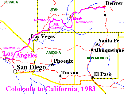 Landed in the middle of a blizzard. It took Cheryl three tries to get up her driveway through the snow into her garage, and we were snowed in for a day. Pretty nice, actually. She was going to do her annual drive to LA again, and along the way we could see scenic parts of Utah, where I had never been before. This included nights at Moab, near Arches National Park, and Mt. Carmel, just east of Zion National Park. The most awesome part was actually driving across the Colorado River through the Glen Canyon National Recreation Area. The next day was the first time I had been through Las Vegas since '75, but we didn't stop. There had still been a lot of snow on the highway in Colorado, and the last ice didn't fall out of the wheel wells until we stopped for lunch west of Barstow.

 The way into Austin, on I-10 and US 290, was a route I hadn't been over completely since the original trip to Austin in 1975. The humidity increased steadily along the way, of course, but it was not noticeable until we got out of the car in Austin. My aunt could hardly believe how oppressive it was, but she hadn't been in Texas in quite a while. It was on this sojourn in Austin that I learned of the death my old classmate, Frank Lambert.

 When Jackie finished her dissertation and got her job at Princeton, we began travelling on the East Coast. This included a couple of fairly long drives, one from Niagara Falls to Princeton and Princeton to Burlington, Vermont, that both took about ten hours. Otherwise, the distances were more moderate.
  On the West Coast, we drove to Big Sur and San Francisco for our honeymoon and then, for various anniversaries, to Las Vegas, Lake Tahoe, the Grand Canyon, and other locations. We also took trips to Death Valley and San Diego.
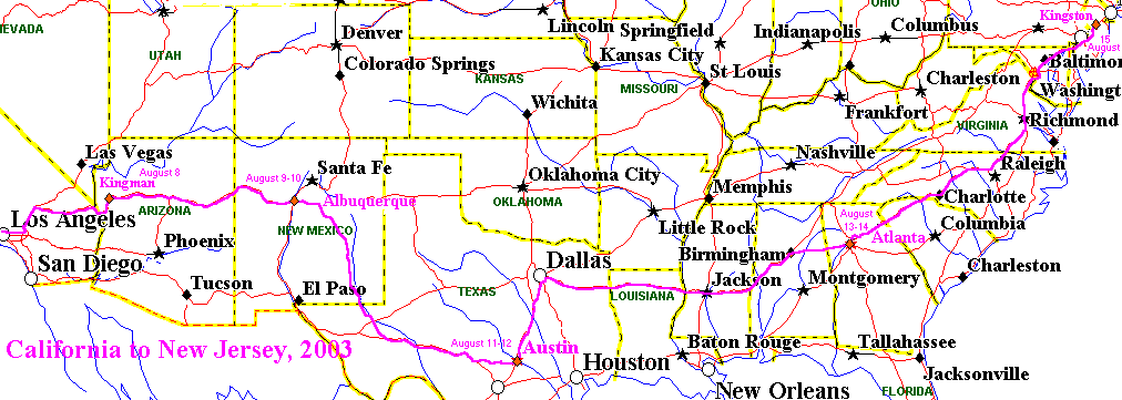
 New Jersey. This ended up taking 15.5 hours, with an unknown amount of that absorbed by Rush Hour traffic in Washington, D.C., which I happened to hit at the worst time of day. Up till then the drive had been largely relaxing. I stopped for breakfast at a Waffle House in Spartanburg, South Carolina, and lunch right inside Virginia. After dark, the drive was a little more stressful. I-95 goes up through Delaware and Philadelphia. Getting near Wilmington, Delaware, however, there was some freeway notice that I-95 was closed and there was a detour. I was thinking that this meant in Philadelphia, which apparently was not the case, but in any case, in the dark, I was not going to be able to read the roadmap to see what this was all about. Fortunately, there is a bridge south of Wilmington that crosses over to New Jersey at the beginning of I-295. I knew exactly where I-295 went, all the way to US 1 in Trenton, so I went that way. It was a good little way, with roadwork messing things up a bit, but I knew the US 1 offramp well when I got to it. It was an easy and familiar drive from there home, to the gravel on our driveway that I had had delivered myself.

Long Drives, 2009


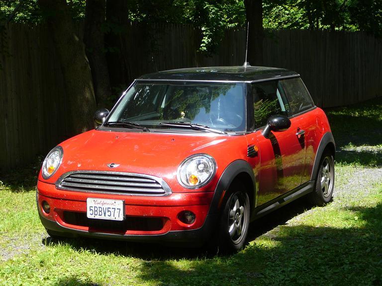 While staying in Princeton, Jackie and I did a trip up to Massachussetts for our 18th wedding anniversary and her birthday. This was, of course, pleasing in its own right, and it was our first experience travelling some distance together in my Mini Cooper. Despite its size, the car was completely comfortable on the long drives, and it was also comfortable for the the two of us -- though it would not have held three people with the back seat folded down to hold luggage. Here is the car in our driveway in New Jersey. I also took it in to Mini of Princeton to see if everything was all right after driving 2800 miles from California. No problem.

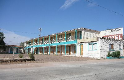 Breakfast this day would be in Winslow, Arizona, at the Falcon Restaurant and Lounge, where I had eaten in 2003. Winslow, of course, is hallowed by the Eagle's song "Take it Easy" in 1972 (written by Jackson Browne and Glenn Frey), as noted above -- where my first wife and I had breakfast in 1975. Unfortuately, Winslow in general strikes me as place bypassed by I-40 and withering on the vine. Thus, at right is one of the old Route 66 motels, now boarded up. The restaurant where I had eaten in 1975 was closed. It is thus hard to visit the town without a feeling of melancholy.

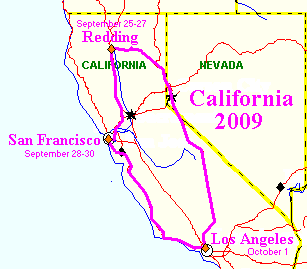 There was to be a good deal more driving in 2009. A two step trip began on September 25th, when I drove up to visit relatives in Redding. I had already done that drive up I-5. It took about 8.5 hours. This was to be more scenic, by way of the Owens Valley, Reno, and Susanville, California; and it took more like 12 hours. There are few places quite like the Owens Valley, with the Sierra Nevada on the west side and the White Mountains on the east.
 After vainly looking for a convenient parking place, I continued on up US 395. There would have been restaurants at Mammoth or June Lake, but they were too far off the highway. So I ended up in Lee Vining, a most dramatic location above Mono Lake, at the foot of the road down from Tioga Pass. This was also the farthest north I had been on US 395 until the year 2000. There I found Nicely's, a pleasant and uncrowded restaurant.
 After a couple of days, I drove down, picked up my wife in Berkeley, and we spent three nights at the Mark Hopkin's in San Francisco. The familiar drive down US 101, stopping at a couple of Missions (San Juan Bautista and San Miguel), completed the trip. Dinner was at Pea Soup Andersen's in Buellton, with the rest of the drive into LA after dark.
 This was only the beginning of travel in the Fall. My wife went on to Japan for a couple of months, and then in November I caught up with her. We visited several sights of great interest, including the site of the Battle of Dan-no-Ura at Shimonoseki and the Byōdō-in temple in Uji, whose reproduction I had just seen while stopping off in Honolulu. This was the longest I had ever stayed in Japan. We both returned to the States exhausted and quickly came down with very nasty colds.
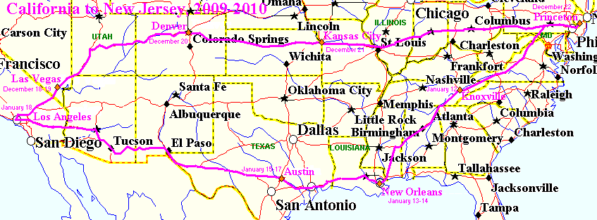
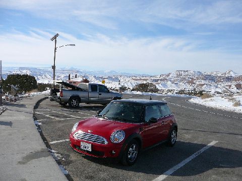 Then it was time for the serious driving.
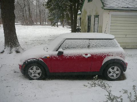 The next day, I ended up driving all the way to Princeton. This took more than 20 hours, but I was more relaxed and handled it better than a similarly long drive in June.

Long Drives, 2010

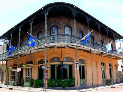 Pere Antoine, at St. Ann & Royal Streets. I still loved their Shrimp Creole, and I also felt that mine was indeed quite good in comparison. I also commended them that now they had real Tabasco Sauce on the tables, not some hot sauce from Texas, which they were using in 1997.
 I even had an intriguing conversation one evening in one bar with the visiting proprietor of the Red Jacket Orchards of Upstate New York. He was on a Winter trip while the orchards were dormant in January.

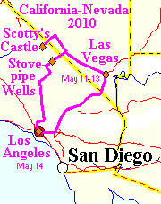 In May, 2010, I decided to return to Death Valley and to Las Vegas. With the former, I wanted to see some things that my wife and I had not seen when we went there in 1993, especially Scotty's Castle, which I had never seen. Leaving LA early and driving up by way of Trona and the amazing, and empty, Panamint Valley,
 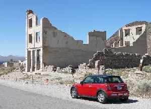 I had breakfast in Stovepipe Wells.
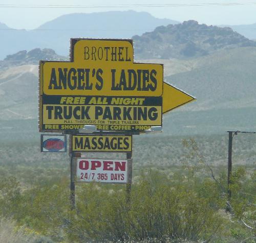 Actually, this was just one brothel, "Angel's Ladies," about three miles north of Beatty, owned at the time by Angel and Mack Moore. Seeing it, I wondered if such things were perhaps as common as gas stations. Not quite. There are still several legal brothels in Nye County, but Angel's closed in 2014. I still have not seen another brothel advertised so openly by the roadside, although I am sure it happens. I never have been to nearby Pahrump, Nevada, whose name is happily commensurate with the all nude shows that are advertised there. Chances are, I'll never get back.
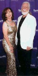 These included Rita Rudner at Harrah's, Penn & Teller at the Rio, and Peepshow at Planet Hollywood -- at least one show, after all, should have some kind of nudity in it.

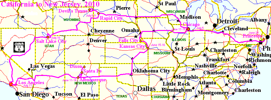
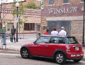 The first step was to see the "Standin' On The Corner Park" in Winslow, Arizona, where I stopped to have lunch. It turned out
  that I had already driven right by the place without realizing it. It is done up very nicely, although it is a little sad to think that this is now Winslow's principal claim to fame. The gift shop across the street had a great selection of Route 66 memorability and, most importantly, refrigerator magnets. Lunch was at the Falcon, as before, although I'm afraid that the place looks increasingly seedy. And the only air-conditioning in the bath room was through an open window.
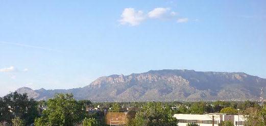 Albuquerque was 12 hours from LA again. The rest stops in Arizona were closed, perhaps because of budget cuts. I spent four nights in Albuquerque to catch up on visiting, staying at a hotel to get a good view of the Sandias, which I really had not seen well since staying in town to visit Trinity Site in 1997. This was a business hotel, which surprised me that the meeting area was inside, without windows, while the bedroom had the view, and the bathroom, without windows, blocked the space where more windows could have been placed. I was puzzled by the design.
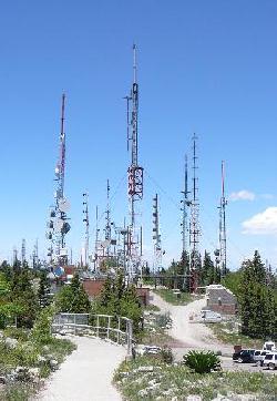 The first full day, my friend Craig drove me up into the Sandias to do a little hiking and to see Sandia Crest. The antenna farm has grown considerably over the years. That night, I went down to have dinner at the Old Plaza in Albuquerque, which I don't think I had visited since the 1970's. The second day, I drove all the way up to Dixon, New Mexico, to visit my friends there again. Now I knew how to find their place. We went into Taos for lunch, although many places were closed because it was Sunday. Back in Albuquerque for the third day, Craig drove us all the way to Santa Fe for lunch. Again, I had not been to one of the main Santa Fe restaurants, in this case The Shed, for many, many years. The food is incomparable, worth the drive from LA just for that alone.
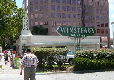 Calvin Trillin favorite, Winstead's Drive-In. I ended up having both lunch and dinner there, to sample different things on the menu. Bryant's doesn't present that opportunity.
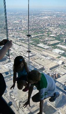 and made my way to Michigan Avenue, it wasn't at all hard getting to the Hyatt Regency on the Chicago River. Never having visiting central Chicago before (I had been in some suburbs, laid over at O'Hare, and flown low over the city, but never been to the Loop), I began with basics, like the Sears Tower, which now unaccountably has been renamed the "Willis" Tower.
 No thanks. The great joy of the visit, however, was visiting the collection at the Art Institute of Chicago. Among many famous paintings, like American Gothic, was other splendid art, like The Bathers [1884] by William Adolphe Bouguereau. I spent the better part of the day there.

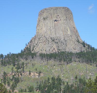
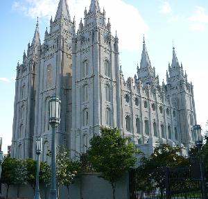 After these excursions and pleasant visits with my relatives, I headed back to California, the first day as far as Salt Lake City. This was the last major place in the country to which I had flown but had never driven before. So this wrapped up one of the projects on this year of long drives -- to drive to such places. And it is always interesting to visit Temple Square and see the Mormon Temple again.
 The next day I headed out past the Great Salt Lake and the Salt Flats. Entering Nevada, I headed south to Ely, where I had breakfast (the cafe is always through the casino). There I picked up US 6, the last desination of the trip, as I have described in detail elsewhere. I was somewhat fearful of the vast empty spaces of central Nevada, and they were indeed empty, but it was all very beautiful and majestic, and a great chance to drive very fast. I never did see any police -- the Turnpike in Ohio and Indiana had been swarming with them.
 The snowy White Mountains, on the border between Nevada and California, came into view not far outside Tonopah, Nevada. Having left Salt Lake City at 4:45 AM, I rolled into Bishop, California, almost exactly at noon. LA was less then four and a half hours away, with only the disturbing discovery at Little Lake to interrupt things.

Long Drive, 2012
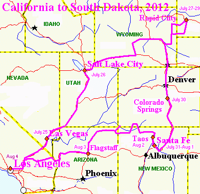 This would provide a chance to cover some ground that I had previously missed. The first leg of the trip was to Las Vegas, where I spent a night at the Cosmopolitan and went to see the show, "Crazy Horse Paris," at the MGM Grand. That was fun. The Cosmopolitan was new, and I had been seeing a lot of commercials aobut it.


The Loretto Chapel
 From my room, in the back of the La Fonda hotel, I was looking down on the Loretto Chapel. This was built by the Order of the Sisters of Loretto from 1873 to 1878. The Sisters were an American foundation, from 1812, and not to be confused with the much older Sisters of Loreto, founded in 1609.
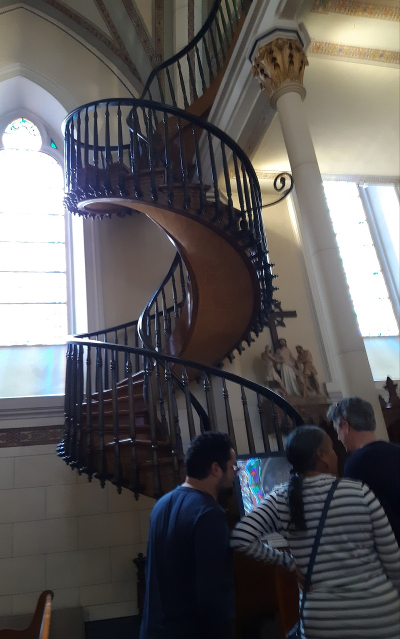

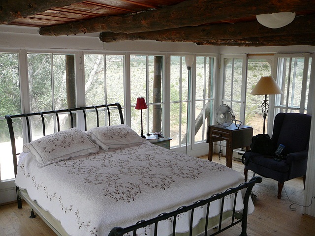 The next day I drove to Taos, where I had never stayed, or visited, again, on my own. I had never gotten a good idea of the local layout, which in this case was not at all surprising. I stayed at a historic site, the Mabel Dodge Luhan House, where various luminaries, like C.J. Jung, had been hosted, and which Dennis Hopper had owned after the death of Mrs. Luhan (1879-1962). Reservations are by individual rooms. I was in the "Solarium," which turned out to be a glassed in belvedere on the roof -- a little exposed and vulnerable to the wind storm during the night but very lovely.
 After sleeping there, I actually woke up at 3:30 in the morning and hit the road. The tire pressure alarm went on again, so I checked the offending tire. I checked it again in Needles, after dawn, and it really hadn't lost any pressure, so I drove on in to LA.

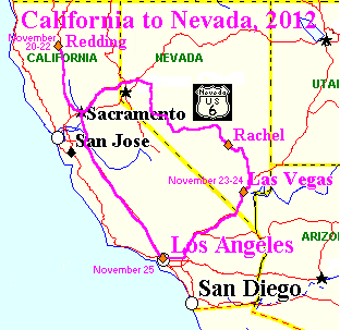 She didn't have to wait long. I was thinking about driving back up to Redding again to have Thanksgiving with my relatives; and I noticed the coincidence that Rita Rudner, who had moved her show to the Venetian, was giving a performance the Saturday after Thanksgiving. So, with a return stay at the Venetian, I couldn't pass this up.
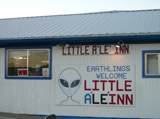 Turning off on Nevada 375 at Warm Springs, a road I had looked down longingly in 2010, I began to notice that the sun was getting rather low in the West. I had not been keeping track of sunset times, and it suddenly occurred to me that I was now well East of the meridian for Pacific Time, which meant that sunset could be substantially earlier than it was in Los Angeles. Actually, I was thinking that sunset would be about 5:30, when it was already down to 4:45 in LA.
 , goes around them to the south, and Tonopah itself is on a spur of the Toquimas, which go up to 11,814 feet at Jefferson Peak, rising 5,861 feet from the valleys on each side.
  This is respectable relief, comparable to much higher mountains. From Tonopah, US 6 actually crosses three ranges, including the Hot Creek Range, and then the turnoff to 375 goes across the Pancake Range into Railroad Valley, which US 6 crosses further North. Rachel is then south across a spur of the Quinn Canyon Range. The unreachable Area 51 at Groom Lake is just South of the Groom Range.

The Decay of Las Vegas
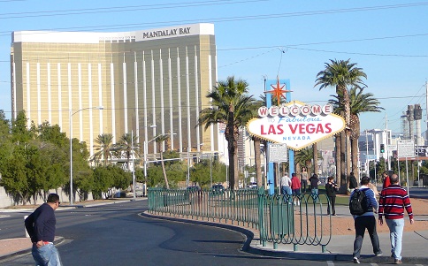 The original plan in Las Vegas was that all the profit would come from people losing their money in gambling. Everything else would be to attract people to gambling. Thus, everything was inexpensive but good. The hotels, the food, the shows. Bring them in so that they would otherwise hand over their money for nothing in return but the excitment of thinking that they just might win big. But the house always wins. The place could be called "Lost Wages" for good reason.

Long Drives, 2013

 and I was on the road, just like in 2003, in a U-Haul truck. Unlike then, I wasn't going to do much visiting -- just with a day layover in Albuquerque -- and I otherwise planned a straight shot back to Princeton. This meant direct on I-40 from Barstow to Knoxville, Tennessee. I-40 actually originates at Barstow; but people unfamiliar with California may never have heard of the place. Or, as we see in the strange account of Lee Child below, their familiarity may involve the impression that Barstow consists of nothing more than a "miserable diner" -- when restaurants in California generally have not been called "diners."
 In Albuquerque, eating Mexican/New Mexican food, I would not have any grounds for complaint about them getting the cuisine wrong. Instead, in Albuquerque I was introduced to the joys of
  Garcia's Kitchen.

 At left is the view out my hotel window, with my truck in the parking lot (and the Holiday Inn in the background). I-81 up to the Pennsylvania Turnpike then avoided all the traffic of I-95 through Washington and Baltimore. I had learned from experience.

When it rains in New York, people get wet.

Lee Child's Las Vegas
 I don't think Child had actually been to Las Vegas when he wrote the book. It is too wrong. First of all, Reacher and his friends are driving from Los Angeles to Las Vegas (a drive that was also done by James Bond, in the opposite direction, as I recall). They stop to eat in Barstow, "at a miserable roadside diner that had no virtues other than it was there and the road ahead was empty" [p.230].
 | World's Tallest Thermometer; Baker, California; 134 ft. tall |
|---|
 Bob's Big Boy -- a venerable and esteemed survivor of 1950's Southern California. I don't know if this was a Bob's when Child would have written the book; but I ate at the same restaurant back in like 1992, and whether it was a Bob's or not (I don't remember), it was a perfectly nice place. As it happens, there was also a
  Bob's in Barstow.
Unfortunately, since my drive, the Bob's in both Baker and Barstow have closed, like the ones in Arizona; and I wonder if the now Michigan based company is beginning to withdraw from California -- although there remain six restaurants in the Los Angeles area, all the way out to San Bernardino. The only one I have ever visited is the one in Toluca Lake on Riverside Drive -- most recently in June, 2023. For one of the original fast food restaurants, your order of hamburger and fries at Bob's comes with a salad, of all things.
 | Bob's Big Boy in Toluca Lake; Burbank, California, June 24, 2023 |
|---|
Meanwhile, the great thermometer, which was not working when I ate at Bob's has been restored by the family of its original builder.
So I don't think that Child had ever driven from Los Angeles to Las Vegas, especially when he seems to think that the road goes through Lake Arrowhead and over Mt. San Antonio, both of which of course are well off I-15 or any other through highway -- and Mt. San Antonio is called "Mt. Baldy" by anyone familiar with Southern California, as Reacher can be presumed to be, but not Child [p.291-292].
Child's lack of sense of Southern California geography was evident in an earlier Reacher book, The Enemy [2004, Dell, 2011], where he says: "[Fort] Irwin was just north of Barstow, which was about thirty miles away across the breadth of the city" [p.419]. Well, Fort Irwin is north of Barstow, but no one looking at any map would think of it as "thirty miles away across the breadth of the city," i.e. Los Angeles. "I figured it would take him about an hour to get us there," i.e. from Los Angeles International Airport. However, Irwin is more like 180 miles from LAX, not thirty, far to the North-East, and one could count on at least a three hour drive, regardless of traffic. "In the end it took us more than an hour to get to Irwin," which is certainly going to be true, but not in the least bit surprising.
Back in Bad Luck and Trouble, Child's lack of familiarity with Los Angeles itself is something we see in comments like "The great city went quiet after they passed MacArthur Park and hit the 110. To their right, downtown was silent and deserted" [p.348]. One could find "silent and deserted" parts of Los Angeles, mainly in residential neighborhoods, but certainly not on any freeway (regardless of the hour), or around Downtown. Similarly, "This was L.A. Twenty-one thousand miles of surface streets, probably fewer than twenty-one thousand yards of sidewalk" [p.350]. It may indeed be unusual to see a lot of pedestrian traffic in large areas of Los Angeles, but generally this means empty sidewalks, not the absence of them. My guess would be that there are fewer sidewalks in rural New Jersey than in Los Angeles; and I expect that the correspondence is close, since the lack of sidewalks in Los Angeles is more typical in residential areas up in the hills. The flatlands, whether in the Metro area or the Valley, not only have plenty of sidewalks but include areas generally dense with pedestrian traffic.
 But back to Las Vegas. Reacher and his friends, who unaccountably cannot get cell phone service along I-15 [p.232], "approached from the bad end of the Strip" [p.233]. Since, coming from Los Angeles, you approach from the south, I'm not sure how the southern stretch of Las Vegas Boulevard is the "bad end." Since they reach the "glittering palaces a half-mile ahead," the "bad end" would have to be about where one cuts over to McCarran International Airport. I've never noticed anything bad about that area. They pull into a hotel "with an Italian name." The Bellagio? Venetian?
Reacher's room was on the seventeenth floor. It was a dark concrete cube tricked out to look like a centuries-old salon in Venice. [p.234]
This makes it sound like the hotel is supposed to be the Venetian,  whose rooms are neither dark, (visibly) concrete, cubes, nor "tricked out" to look Venetian at all, as in the image at right, looking from the windows across the split-level sitting area into the bedroom. Unlike some business hotels I've been in (as noted above in Albuquerque), the sitting area and desk are by the windows, with the bed further in, as seems to me more reasonable. Nor are the rooms in the Bellagio, which are smaller, like that.
Even worse, Child goes on to say, "the lights in the bedrooms had been dim. A guest upstairs reading was no use to anyone" [p.240]. Now I find this representation particularly interesting, for I have never found a dim room in Las Vegas; and the Cosmopolitan has an elaborate system where all the lights in the room can be controlled from the television set -- a hotel where if you prefer the bed to be by the windows rather than the sitting area, you can get that. It has already struck me that the reading light, particularly at the Venetian, is unusually good for a place where I would indeed expect the management to render the rooms uninviting in that respect. I ran into the same thing in Atllantic City. So Child, apparently having not been to the hotels, went with what he expected, and even what is reasonable, not what is actually there.
Otherwise, Child's problem, as ab initio, is the scale and appearance of the Strip. Thus, Reacher and his friends, walking up the Strip, "passed the high-end hotels one by one, moving through sketched facsimiles of the world's great cities all in the space of a few hundred yards" [p.268]. Since the Strip runs a good three miles from Sahara Avenue to Tropicana Avenue (3.16 miles according to my CD-ROM atlas), with the Statosphere north of this and the Excalibur, Luxor, and Mandalay Bay south of it, this is hardly "a few hundred yards." In fact, three miles is 5280 yards (and 3.16 mi. is 5561.6 yards), and that is well beyond convenient walking distance, especially in the Nevada summer heat.
We also hear that they are directed "back to the cheap end of the Strip," "where the Riviera had been" [p.244]. But if the "bad end" of the Strip was south, the Riviera, which is still there as I write [but has now, in May 2015, been closed], is at the north end. Child does correctly describe that area as one where hotels have been torn down, including the venerable New Frontier (1942-2007, previously the "Last Frontier," until 1955, and from 1967 just the "Frontier"). Perhaps he was confusing that with the Riviera. But he gets into other trouble. "The roadway and the sidewalks were being straightened as the work progressed. The new lanes continued uninterupted. The old route looped through rubble" [p.248]. But Las Vegas Boulevard there has been straight as long as I can remember it, since the 1950's -- with a single bend that is now in front of the Venetian.
But the most astonishing thing to me about this whole treatment of Las Vegas by Lee Child is the following passage:
Vegas in the morning looked flat and small and exposed under the hard desert sun. The light was pitiless. It showed up every fault and compromise. What by night had looked like inspired impressionism looked like silly fakery by day. The Strip itself could have been any worn-out four-lane in America. [p.261]
Now, anyone is free to make the aesthetic judgment that Las Vegas displays "silly fakery," but the idea that the Strip would look "flat and small" or anything remotely like "any worn-out four-lane in America" is preposterous. The Strip makes Giza (also under pitiless desert light) look like the plaything of a particularly unimaginative and lazy child -- Vegas stopped with one pyramid and moved on to other things. And recently Las Vegas Boulevard has so many lanes that I am unsure how many. Eight? Ten? It is unlike any other place in America, or anywhere else in the world for that matter, that I know of; and I've been to the Ginza and Shinjuku on a Saturday night. Perhaps Abu Dhabi now has something like this.
So Lee Child ends up promoting a certain vision of Las Vegas, which, for all the faults that one can imagine for the real place, is contradicted on many points by the reality. What surprises me is not that Child should put down such distortions on paper and get them published -- he's English, after all -- but that a rich, successful, and well traveled writer would not have been to Las Vegas! Or Los Angeles?! It is perhaps a tribute to one's creativity and chutzpah to conjure up a place based on vague impressions, hearsay, and reputation; but millions of people visit Las Vegas every year, know what the place is like, and the percentage of them that read Jack Reacher books is liable to be considerable. They will all be scratching their heads. Even more if they've stopped to eat in Barstow, Baker, or Primma, Nevada, at the State Line, or walked down a sidewalk in Los Angeles. Of course, not everyone can be a Tom Wolfe, who visits and studies the places and people he writes about -- it is incredible that he would get Las Vegas so wrong. But then Tom Wolfe doesn't publish a new book every year.

It may be that Lee Child has heard back about the absurdity of his treatments of Las Vegas and Los Angeles. For a number of books he avoided trouble by setting his stories in fictional locations, largely in the American Midwest. He still sometimes would say things that could not be true, like the unavailability of cellphone service in Kansas; but then Kansas is not named, and one is left to infer the location. So the treatment has at least some distance from claims about reality.
Child's later book, The Midnight Line [Delacorte Press, 2017], returns to some real locations, unfortunately with a few of the same problems evident in his old treatment of Las Vegas and Los Angeles. The principal real location in this respect is Rapid City, South Dakota. There are two kinds of errors. One is the old problem of false geography. Can't Child read a map? Jack Reacher has hitched a ride along I-90 and gotten off at the turn-off to Rapid City. Child says,
As so often, getting from the highway to the city was the hardest part of the trip. [p.42]
Really? It is all of two miles from I-90 to downtown Rapid City. If I can walk 4 miles-an-hour, so can Reacher, which means he can get there in half an hour. Child doesn't actually say how far it is from the highway to downtown; but with the impression that it is too far for Reacher to walk, we get Reacher's reflection about a possible ride:
...but also weirdly happy to actually go ahead and pick a guy up and drive him five or ten miles. [p.43]
So the distance from I-90 to downtown Rapid City is "five or ten miles"? That is the only range of distance we are given, which would make walking it a little less appealing -- when the truth is that someone like Jack Reacher would think nothing of walking the real distance.
Meanwhile, Child has said some other odd things, like calling the Sheriff's Department in Wisconsin the "county police department" [p.4] or a Sheriff's Deputy the "County Police" [p.16]. I don't think an American would say any such things. The "county police" anywhere means the Sheriff and Sheriff's Deputies. So Lee Child, despite an American wife and now living in the United States, hasn't quite picked up on that.
But, back to Rapid City. The other real problem I see there is that Child says absolutely nothing about Rapid City that would distinguish it from hundreds of other such towns. And this is especially odd because Rapid City has something very distinctive about it, which is statues of the Presidents of the United States on almost every street corner in the downtown area -- something undertaken because Rapid City is the tourist gateway to Mt. Rushmore. Whether Jack Reacher was new to Rapid City, or already familiar with it, the presence of 44 Presidential statues is something he would certainly notice, if new, or nevertheless comment on, if he already knew about them. Instead, as much detail as we get about the city, it is mostly of the miserable sort that is familiar from the tone of Child's treatment of Las Vegas and Los Angeles, but without outright falsifications -- except for the distance problem.
According to The Wall Street Journal, Lee Child lives in New York City but now also has a home in Wyoming ["Saved by the Beatles in Gray Britain," Mansion, November 10, 2017, p.M1]. This may be why he decided to write about the area. A lot of The Midnight Line is set in Wyoming, with which I am less familiar than with Rapid City, Las Vegas, or Los Angeles. I detect some small problems, but I will leave any critique there to others.
Another Brit writing about Los Angeles who sounds like they may not have been there is Claire North. A pen name for Catherine Webb, North is responsible for The First Fifteen Lives of Harry August [2014], Touch [2015], and The Sudden Appearance of Hope [2016]. These are clever and well written books, although sometimes marred by gratuitous political statements; and Harry August rests on some dubious premises about developmental economics and physics (she seems to mistake a quantum defined atom for a Leibnizian monad). Be that as it may, my concern here is Los Angeles.
In Touch, the protagonist, a body hopping ghost known as "Kepler," is sitting in "the Scarlet and Star Diner on North Arlen Boulevard" in Los Angeles, eating badly cooked eggs [Redhook Books, p.121]. There is no such diner or boulevard in Los Angeles, or, as far as I can tell from Google, anywhere. Fair enough.
We have, for some reason (e.g. antipathy for but ignorance of Los Angeles), fictional locations -- although places that might be called "diners" in New York have generally been called "coffee shops" in Los Angeles -- like the real but since demolished coffee shop (the Hawthorne Grill) in Pulp Fiction, or the long-lived and famous, But then, at right, we see that the beloved but since closed Evergreen Diner on West 47th Street in New York billed itself as a "Coffee Shop Restaurant." For better eggs, I recommend Canter's Deli on Fairfax (another latenight destination after local dates). Nothing fictional there.
Claire North, writing now as Kate Griffin, has no such need in London, where we find Matthew Swift, the soon to be Midnight Mayor of London, conferring with allies at the My Old Dutch Pancake House on High Holborn, just a few blocks towards the Thames from Russell Square [A Madness of Angels, Or, The Resurrection of Matthew Swift, Orbit Books, p.316]. Griffin's knowledge of London is minute, in all the more stark contrast to the treatment we see of Los Angeles by Claire North.
Then, back to LA, we get:
Endless straight lines from nowhere particular to nothing much especially.
Even the places that should be green -- parks and "recreation areas" -- are no more than a slab of fenced-off concrete where the kids sit and drink while waiting for something more interesting to pass them by. [p.128] So perhaps Catherine Webb doesn't like LA, but has she been there? It's a nice drive down Sunset Blvd., not at all straight, past a lot of very green trees, and it goes to the beach, which few people would think of as "nothing much especially," especially if they're from Denver. There are a lot of yards and a lot of lawns all over LA (as we see in Steve Martin's L.A. Story [1991]), and they all have their trees, even in poor areas.
Seems like I see the concrete playgrounds more in New York, especially for schools that are tucked in among buildings, with no real grounds of their own. Recently, I've walked by P.S.6 on East 82nd Street in Manhattan: All concrete, fenced in playground. In Los Angeles, I never had to attend a school like that. My Junior High (Rober A. Millikan) and High School (Ulysses S. Grant) both took up entire blocks, with extensive grounds, and lots of grass and trees.
Later "Kepler" likes Berlin, where part of the praise is that many post-War trees have been planted [p.159]. But Los Angeles is dense with trees, and in the classic view of the San Fernando Valley from Mulholland Drive, one might at first wonder if they are seeing anything else. I expect that there are a lot of parks in LA where "kids sit and drink," and Echo Park might even be one of them; but no one would mistake Echo Park, with its lake, fountain, and trees, as a place of concrete. Instead, the television show Castle [2009-2016], filmed in LA-for-New York, seems to have used Echo Park to stand for Central Park. Perhaps I have missed where Central Park is covered in concrete, or how one of the concrete LA parks could impersonate it.
I don't think LA has as many parks as it should, but it also features a mountain range, the Santa Monica Mountains, that slices right through the center. Not many cities have anything of the sort. And you can hike around for quite a while there without realizing you are in a city, much less the second largest city in the country. The extensive grounds of Griffith Park (happily not named after D.W. Griffith) are at the East end of the mountains.
For all its appeal and delightful views, the Santa Monica mountains pose a threat. A lot of it is wild brush. In the dry climate, this dries out, and burns. The Santa Ana winds come and blow the fires down towards metro LA. The Bel Air Fire of November 1961 was dramatic enough -- I could see it burning from my Junior High in Sherman Oaks -- but in January 2025 the Palisades Fire all but wiped out the high end community of Pacific Palisades. This burned down hundreds of expensive homes, many owned by Hollywood celebrities -- who had voted for the Democrat government whose follies prevented brush clearance and preventative controlled burns in the off season. The fire also threatened Malibu, Brentwood, and Santa Monica. I have otherwise noted the loss of the Moonshadows restaurant in Malibu.
On the other hand, Webb's scenes in New York City don't use fictional streets. We hear about a "diner off Lafayette and East Houston Street" [p.381]. I don't know about the diner, but the location is real enough. Walk down the street to Katz's Deli. But Webb's familiarity with New York is itself at least limited. Amid glowing praise for the greatness of the Metropolitan Museum of Art, we are told, "All of which said, the entrance fee, as I line up in the queue... would deflate anyone's good mood" [p.397].
However, the Metropolitan Museum of Art did not have an entrance fee. The Museum's website said, "If you buy tickets at a museum ticket counter, the amount you pay is up to you. Please be as generous as you can. Suggested admission is $25 for adults." Legally, admission to the Museum was free; but you were encouraged to donate the "suggested admission." There have been complaints that the Museum obscures the fact that you need not pay at all -- part of the deal where the Museum sits on land owned by the City.
As it happens, late in 2017, the MET decided to charge admission for people who are not residents of New York, Connecticut, or New Jersey. Many people it seems, had heard about the admissions policy, or had read the signs carefully, and were not paying the "suggested admission." Also, through mismanagement, the Museum had wasted a lot of money. Someone was going to need to pay. So the next time Catherine Webb shows up, she will need to pay, although the fee will still hardly be enough to "deflate anyone's good mood."
So, back to our issue, either Catherine Webb, like Lee Child, was relying on poorly imagined clichés to express hatred or distaste for a place, Los Angeles, she had never been, or she had only been to Los Angeles so briefly that she couldn't and didn't even take very much in.

Claire North's Los Angeles
 indeed iconic, Ships Coffee Shop on Wilshire Blvd. in Westwood (a latenight destination after local dates)
I hate LA.
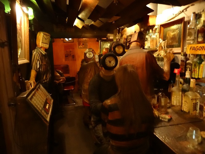 |
|---|
| "The Beanery," 1965, by Edward Kienholz (1927-1994); Stedelijk Museum, Amsterdam |
And in fact her book mentions no actual streets in Los Angeles, not Wilshire, Laurel Canyon, Sunset, Ventura, Sepulveda, Hollywood Blvd, etc. Perhaps in "liberal" literary circles it is au courant to denigrate Los Angeles, but for anyone who actually knows the place, it makes these people look bigoted, ignorant, and ridiculous.
For the rest of us, there is Randy Newman's "I Love L.A." [1983]. Newman, of course, is someone who may always be suspected of satire; but, driving down Victory Blvd., which, admittedly, is rather straight, with "a big, nasty redhead" at one's side, I might have a bit more pleasure than waiting on a steamy, dirty subway platform in New York, in August, watching rats run along the tracks, with some smelly, disheveled crazy guy asking for money, redhead at my side or no.
Claire North's Fractured Arabic
Cassandra Clare, a pen name for Judith Lewis, has strange things to say about Los Angeles in Queen of Air and Darkness [Simon & Schuster, 2018]. Or, perhaps it is just Malibu, but with implications that reach to Los Angeles.
This book is the twelfth book in a cycle of trilogies, beginning with six "Mortal Instruments" books, three "Infernal Devices" books, and the third in three "Dark Artifices" books. These are all about "shadowhunters," who are warriors who use some supernatural powers to fight demons and other embodiments of supernatural evil. These books rate as "Young Adult" fiction, as well as Fantasy; and thus they focus on teenagers and their characteristic problems, complicated by these supernatural elements.
The first book in all of these was made into a movie, The Mortal Instruments: City of Bones [2013]. This badly rewrote the story and did not do well as a movie. It only gets a 58% rating in the audience reaction at Rotten Tomatoes. The possibility of further movies, despite the success of the books, thus does not seem good. However, starting in 2016, there has been a television series, Shadowhunters, which did rather better than the movie, although it was cancelled after three seasons. Well, better than Firefly.
The issue I notice concerns the location of the Shadowhunter "Institute," i.e. headquarters, for Los Angeles, which is in the hills above Malibu. The Ocean is visible from the premises and is within walking distance. The problem with this involves the other direction. Looking inland from the Institute, you can see desert. Indeed, the desert comes rather close to the location of the Institute, with sand and cactus on its mountain.
This is absurd. Looking north from the hills above Malibu you see, first, other hills in the Santa Monica Mountains, and then, if you get all the way to the last of them, you look down into Thousand Oaks, Calabasas, and other locations along US 101, as it runs from the San Fernando Valley off to Ventura. No desert. Instead, the climate in the Los Angeles Basin and surrounding hills is Mediterranean, which means cool, rainy winters and hot, dry summers. Much of the year, you see a lot of dead grass, brush, and oak trees, not sand.
If you want to look down from mountains into the desert, you need to go north, entirely beyond the Simi and San Fernando Valleys, into the San Gabriel Mountains, which are larger and more extensive than the Santa Monicas, and so see off into the Mojave Desert. It can be done, but not easily from Malibu. At the same time, although there are sand dunes in some places in the California deserts, most of the Mojave is just dirt. And Joshua Trees are more characteristic than cactuses. But we get sand and cactus and no Joshua Trees in the book. You see more what the desert looks like in the strange movie, The Bad Batch [2016].
Why Cassandra Clare relocates the Southern California desert I cannot say. Unlike the British authors above, she has lived in Los Angeles and frequented it even when living elsewhere. I can only guess that, (1) she has a poor sense of geography, even for Los Angeles; (2) she has altered the geography with poetic license, although the presence of the desert plays no role in the stories; or (3) the desert has been brought close by magic, even though the story doesn't say so and, again, its presence plays no role in the events of the story -- as the presence of the Ocean indeed does. Or, perhaps, (4) she hates the San Fernando Valley and has cut it out of her mental map, bringing the desert in from over the San Gabriel Mountains.
So, in the end it all seems strange and incongruous.
A nice touch in the Shadowhunter books is that there is a kind of homeland for the Shadowhunters. This is "Idris," with its capital of "Alicante." Idris is described as somehow lodged between France, Germany, and Switzerland, although invisible under a magical glamour. What I like about it is that the location seems to be identical to that of the fictional Duchy of Grand Fenwick, from the Mouse That Roared books and movies. Thus, arriving in Idris, I would like to imagine finding Peter Sellers (1925-1980) or Terry-Thomas (1911-1990) waiting to greet me, instead of the grim and unpleasant characters often featured by Cassandra Clare.
The premise of Cassandra Clare's "Shadowhunter" books is that the powers of the hunters have been given them by an Angel, the angel Raziel, רָזִואֵל, Rāzîʾēl, who occasionally reapears in the stories, has actually mated with humans (or had them drink his blood), so that the Shadowhunters actually have "Angel blood," and who is regularly invoked by the characters.
Otherwise, actual religion is conspicuously absent from the stories. Although Raziel figures in genuine Jewish tradition, there is nothing of Jewish, or Christian, practice or belief in the corpus -- no more than in Star Trek. God as such in not invoked or referenced, and the names "Christ" or "Jesus," do not, as far as I can recall, ever even get mentioned -- except as an oath. Nothing of Jewish or Christian ritual or practice occurs, although the Shadowhunters may piggyback on things like "hallowed ground."
Indeed, in the first Shadowhunter book, City of Bones [2007], one of the characters denies belief in God, or even in angels, despite the power of the Shadowhunters coming from "the Angel," without whom it would be inexplicable -- runes of power placed on ordinary "mundanes" drive them mad. At the same time, the same character reveals that Catholic churches, and apparently other religious institutions, contain secret caches of weapons to fight demons; which seems to mean that if the character doesn't believe in those religions, they actually do believe in him.
In a sense, the mismatch of Shadowhunters and religion is particularly prominent in that there is a lot of homosexuality in the stories, without the slightest hint that religion might have any kind of negative attitude about this. There are homosexual marriages that are featured, and Queen of Air and Darkness actually culminates in such a wedding.
Nevertheless, in City of Bones, one of the characters is a homosexual, and this is regarded as something to be kept secret, with its disclosure resulting in some possibly dire consequences. Thus, the attitude represented in the books has changed considerably over time, to the point where the earlier take is no longer even acknowledged.
This gets more marked in the fifth triology of the Shadowhunters books, The Last Hours, which features a Lesbian couple and a homosexual male couple, out of a small group of friends, as well as conventional matches. This is more striking in that it takes place in the previous century, like The Dark Devices triology, when attitudes about homosexuality would have been severe. Indeed, one character is being blackmailed about his homosexuality, but then there are no consequences, except for the blackmailer, when this is publicly revealed. It is hard to resist the sense that Cassandra Clare could not resist projecting contemporary, politically correct, attitudes back to the past, in order to virtue signal.
The third book of The Last Hours, Chain of Thorns, curiously seems to end with some direct Divine Intervention, by which the Demon Belial is killed. God otherwise, rarely mentioned, also otherwise never intervenes in events.
Along with the growing prominence of homosexuality in the books, one of the characters in Queen of Air and Darkness is a "trans" woman; and we are given a dose of "trans" ideology, as explained to other characters, that "gender" is something that is rather arbitrarily "assigned at birth," as though it is based on nothing more substantial than choice. No one had any hint that this character was "trans," despite the fact that even cosmetic surgery cannot alter a number of male characteristics, like size, height, and larger shoulders, hands, and feet. There are indeed rather "mannish" looking natural women, and naturally effeminate men, but not all "trans" persons can count on fitting into one of those categories. With many, their origin is painfully obvious, even after considerable surgery.
Judith Lewis is, of course, free to believe whatever she wants. There is a certain paradox, however, in wishing to invoke features from religious traditions without any acknowledgement of what the overall nature and attitude of those traditions might be. This absence, unfortunately, might remind us that the political realities of "gender" ideology are to vilify and attempt to silence, if not harrass and assault, any disagreement or opposition to the ideology or its program -- which program includes irreversible medical treatments of minors, which results in their sterilization and a lifetime of medications, if not surgeries. Thus, the "trans" character in Queen of Air and Darkness, when divulging her condition to others, does not mention her dependence on "mundane medicine" for the hormones that are necessary for her to maintain her cosmetic "gender identity." We hear nothing about that.
This degree of political correctness, while agreeable to the increasingly totalitarian nature of "progressive" politics, may seem gratuitous, if not offensive, to other readers of this fiction. But it also can make for interesting discussions, when strict Catholicism, for instance, regards all magic, whether supposedly used against demons or not, as actually the doing of demons and corrupting in itself. Raziel is not an angel of, for instance, the Thomist theology of angels, and thus may be suspected of deception. Impersonation by a demon is something that actually occurs in this book. Shadowhunters may deny actually that they do magic, but magic is part of their instruments.
Also, we get the sense that without magic there is no defense against demons, when that is precisely what rituals of Exorcism are for. When Jesus casts out demons, or when Van Helsing shows a Cross to a vampire, was this by magic? Apparently not. We never see any ordained priests in these stories, despite references to "hallowed ground," for which the ordained are necessary.
We may not expect proper and honest theology in Young Adult Fiction, but the general impression about it may be as another secular and irreligious assault on tradition, whether one takes the magical stuff seriously or not.
I was reminded of Cassandra Clare saying that you could see the desert from the hills above Malibu when I was reading Unchained Fury by Bill Runner [Runner House Books, London, 2023].
Runner's protagonist, retired U.S. Marshall Axel Blaze, is driving to the California Dry Creek Prison, which seems to be a fictionalized version of the actual Folsom Prison, which is East of Sacamento in the Central Valley of California.
This description, of course, leaves out most of the Central Valley, which is not desert, and the entire Sierra Nevada mountain range, bringing the desert and the State of Nevada into convenient driving distance of San Francisco, which they are not.
So, as with Lee Child and Cassandra Claire, whoever wrote this seems to have some trouble reading maps, let alone possessing first hand familiarity with the geography of California. At the same time, Interstate 580, while passing over the Coastal Range, doesn't even get as far as Modesto, terminating with a junction to I-5. If you are driving up I-5 and want to go to San Francisco, you would turn off at I-580.
And all this seems gratuitous. It doesn't add anything to the story to leave out the highest mountain range in the 48 States, or to put the equivalent of Folsom Prison out in the Mojave Desert. Other details are reasonably fictionalized. Runner has a "death row" at his Dry Creek Prison, and executions indeed used to be carried out at Folsom -- although now that has been the job at San Quentin for some time. Folsom itself has been immortalized by the Johnny Cash song, Folsom Prison Blues (1955), which he later sang at the prison itself (1968).
In fact, Folsom Prison is about a two hour drive East of San Francisco, which is what Runner gives for his "Dry Creek Prison" [p.112]. To get to the desert, however, is more of a production. It is a good five and a half hours to Mojave, by way of Bakersfield and Tehachapi. Even Reno is almost four hours, by way of I-80, over the grimly historic Donner Pass.
The biography material for Mr. Runner does not include anything about his birth or even residence. He seems much more familiar with the United States and its institutions than Lee Child, but his publisher is given in London ("Runner House Books") and occasionally Britishisms creep into the text -- like "spanner" for "wrench," "post" for "mail," "crisps" for "chips," "car park" for "parking lot," "boot" for "trunk" (of a car), and "windscreen" for "windshield."
In fact, since Runner gives his e-mail address in all his books, it was possible to write him about this, to which I got an answer that, indeed, he is English.
Otherwise, we see a detail about San Francisco that indicates a lack of intimate familiarity with the City. More than once, we hear about fog coming in off the Bay:
Indeed, we hear about this in the very first line of the story:
However, the fog in San Francisco does not come off the Bay, but off the Pacific Ocean. You can stand in San Francisco, with the fog coming in around and over you, and look across the Bay at the sun shining on Oakland. Also, the peninsulas north and south of San Francisco are often protected by mountains from the fogs that envelope the City.
The location of Runner's observation about the fog late in the book is San Mateo, which is down the peninsula from San Francisco. Standing there or in Palo Alto, the location of Stanford University, one can see the fog cresting the mountains to the West. If that doesn't spill over, you will remain in sunlight. Similarly, the Franciscan Mission at San Rafael (used for much of the filming of American Graffiti [1973], instead of any location in the Central Valley, where George Lucas grew up, in Modesto, and where Graffiti was supposed to be set) was founded as an asistencia where Indians could escape the literally sickening fog and cold of the San Francisco Mission (Dolores). San Rafael, of course, is on the sunny leeward side of the coastal mountains.
Runner's introduction of the fog, however, suffers from an inconsistency. He describes it as covering the Golden Gate Bridge first [p.3], but then "From there, like the stupor takng over the consciousness of a junkie, the fog oozed over the rest of the city" [pp.3-4]. Only if the fog were coming off the Ocean would it cover the Bridge before the rest of the City.
Unlike the problem with the Central Valley, Mr. Runner could not know about the dynamics of the fog around San Francisco by just looking at a map. You would need a meteorological treatment of the area, or you need to have been there, or at least consult with someone who has. All in all, it's not that complicated. But if Mr. Runner is British, it is in general hard to tell from his books.
However, just as Lee Child doesn't seem to know that law enforcement at the County level is generally in a Sheriff's Department, Ruuner sometimes seems unaware that there is a County level of government larger than cities but smaller than States. Axel Blaze calls the police and, not being in a city, it is the "State Troopers" who show up. Law enforcement at the State level itself varies from State to State. In California, there is the California Highway Patrol (the CHP). In Texas, there is the Department of Public Safety (DPS), which includes the legendary Texas Rangers. Thus, some research is needed on who is involved, depending on what State you are in. However, you will usually see Sheriff's Deputies before any State police show up. Indeed, in California, some cities are too small to have their own police department, and they contract with their County to be policed by the Sheriff's Department.
On the other hand, in some States, like New Jersey, the State is divided into Townships, where there is no unincorporated County land such as is under Sheriff's Department jurisdiction elswhere. In New Jersey, Sheriff's Deputies are mainly officials of the County Court system, staffing courts, serving processes, etc. Thus, Axel Blaze calling the police in New Jersey would always mean that the local Township Police Department shows up, unless he is in an incorporated Borough or City with its own Police Department.
A striking feature of Runner's books is use of "Close Quarter Combat" (CQC), which I had never heard of, is not mentioned in the Levon Cade or Mitch Rapp books (by Chuck Dixon and Vince Flynn, respectively), but is a real thing. Axel Blaze often disables opponents, with broken bones or dislocated joins, rather than killing them. Also, Blaze frequently disarms opponents who stand too close to him with guns.
That mirrors one of my favorite moments in the movie Skyscraper [2018] with Dwayne Johnson. Someone is holding a gun on Johnson, who tells him, "You are too close." Then he takes his gun. Similarly, in The Equalizer [2014], at least twice Denzel Washington disarms people who are holding guns on him. I saw this actually happen on a surveillance video from a convenience store, where a young veteran disarms a robber, who runs away.
The opposite is what we see near the end of Ready Player One [2018]. There the evil, murderous corporate boss wants to kill the hero gamers who are on the verge of gaining control over the virtual reality where everyone lives much of their lives. However, this fellow is alone and surrounded by a hostile crowd. But he pulls a gun and waves it around, causing the crowd to fall back in terror. However, this is absurd. Anyone could run up behind this guy and clobber him, or several people could grab all his limbs at once, break his fingers, and disarm him. A surrounded lone gunman does not have much of an advantage, especially if anyone in the large crowd themselves happens to be armed -- but they must live in a "liberal" jurisdiction where only criminals have guns (since the Left loves and admires criminals).
Otherwise, apart from the Axel Blaze stories, the only movies I can think of where attackers are left with broken bones are some early Steven Seagal films (before Seagal became a fat, stupid, asshole). Again, Denzel Washington, in The Equalizer 2, seems to be taking down men in ways that look like Axel Blaze moves, although we don't get good looks at, let alone descriptions of, the results.
Otherwise, even martial arts protagonists, like Jackie Chan, often knock down attackers just to have them get up and attack again, and again. Real knock-out blows do not seem to be in their repertoire, let alone the kind that break bones or joints, or kill. But villains do not get up with Axel Blaze.
Runner says that his wife suggested that this sort of thing, of repeated attacks, which, while common in Hollywood movies, seems unrealistic. Blaze can take down attackers with one or two hits, and we are told how. Nobody wants to get hit in the throat.
Another feature of CQC turns up in relation to the 12th book of the Levon Cade series, Levon's Scourge. I love the Levon books, but in this book he is captured by a Mexican drug lord in a way that doesn't seem possible for Axel Blaze. Cade is directed to ride in a van for a meeting with the drug lord, but when the door is opened, he realizes he's been double crossed and his friend, beaten and tortured, is inside the van. Cade reaches for his gun behind his back, but his arm is pressed to his back by a guard behind him. He is captured.
First, even if Blaze does reach for his gun, if the guard is trying to immobilize his arm, this means that he grabs the arm, while turning into an attack. The guard's hand or arm is then broken, and the guard himself can be used as a shield if the other guards try to shoot him. He possibly can use the guard's own gun against other attackers.
That is how I see Axel Blaze handing the situation. Indeed, in close quarters, I would not see Blaze going for his gun, which wastes a moment what can be used more immediately against the man behind him. Blaze often takes advantage of opponents who reach for a gun, creating a moment and opening themselves to direct attack.
Otherwise, in thes story Levon Cade is captured and is going to be fed to pigs through a wood chipper (shades of Fargo [1996]), until there is a deus ex machina to delay his death. Then he can use his skills to turn the tables. But I don't like the deus ex machina. Blaze always tells people that he is lucky, but we see that it isn't luck. His moves are calculated, and explained. Levon Cade cannot always count on luck -- although it doesn't reach to the absurdities of the luck of Aloysius Pendergast.
Perry may be best known for the series of Jane Whitefield novels. Jane lives in the city of Deganawida, which is a fictional version of Perry's own hometown, Tonawanda. There are nine Jane Whitefield novels, with a tenth due posthumously in 2026.
While I like the Jane Whitefield novels, which I have mentioned elsewhere, many of his standalone stories are set, at least in part, in Los Angeles, where Perry lived the last years of his life. This particularly caught my attention when The Bomb Maker [2018] features an early scene at a gas station at the corner of Laurel Canyon Blvd. and Moorpark St. in the San Fernando Valley, where I grew up. This was a very familiar location, and I wrote to Perry about it. He answered, and he also mentioned that the old Du-par's restaurant down on Ventura Blvd. had recently closed, which had been there since 1948. I've been back to Los Angeles twice since then, and have gone to eat at the original Du-par's at the Farmers Market, but it is a shame to lose these old landmarks. Many such places in Los Angeles are now gone, just as several of my favorite places in New York City are now gone.
Since Perry often has a "Studio City detective," rather than the traditional Raymond Chandler "Hollywood detective," I have gathered that he actually lived in or near Studio City. Many books feature locations nearby, or elsewhere in the San Fernando Valley. Writers, as we have seen, who disparage Los Angeles, perhaps wihtout having ever been there, have no more sense of the Valley than they probably have of Alamogordo, New Mexico, or Marble Falls, Texas. Indeed, like the cast of Clueless [1995], Angeleños who live south of the Santa Monica Mountains tend to have the same attitude.
Thus, just as I like Perry's books, I have a special place in my heart for his treatment of Los Angeles, which is really neither positive or negative, but just treats it as it is -- or at least was, before the Democrats set about destroying it.
Return to Autobiographical Statements

Cassandra Clare's Los Angeles

Cassandra Clare's Ideology

Bill Runner's California
We headed east on the I-80 for a few miles before taking the exit for the I-580. The highway snaked through empty stretches of land dotted with vineyards and orchards. We soon left the coast way behind us, heading east toward the Nevada border. The landscape shifted dramatically as we approached desert country. The road stretched out like an endless ribbon, meandering through the barren terrain, with sand and rocks as far as the eye could see. [p.200]
It was that early evening time again when the wisps of fog that must have begun to emerge from the San Francisco Bay an hour ago had started to thicken. [p.322]
A fog had begun to roll in from the San Francisco Bay, creeping silently through the city's streets... [p.3]


Thomas Perry's Los Angeles
 Thomas Perry (1947-2025) was a mystery writer, born in Tonawanda, New York. He died rather suddenly on September 15, 2025, from an aortic dissection, at the relatively young age of 78. He thus joined Jim Henson (1936-1990, 53), John Ritter (1948-2003, 54), and John Hughes (1950-2009, 59) in a sudden and untimely death from heart problems -- although not as untimely as them, whose deaths were particularly tragic.

Copyright (c) 2004, 2009, 2010, 2012, 2013, 2014, 2015, 2016, 2017, 2018, 2020, 2021, 2022, 2023, 2024, 2025, 2026 Kelley L. Ross, Ph.D., Postumus Friesianorum, All Rights Reserved